Condé-sur-Huisne geodata
Condé-sur-Huisne (Normandy) is a populated place; located in France in Europe/Paris (GMT+2) time zone. With population of 1,202 people, there are 7519 cities with bigger population in this country. Compared to other cities in France, 66% of cities are located further ↓South; 70.2% of cities are located further →East and 52.3% of cities have higher elevation than Condé-sur-Huisne. Note1
Administrative division(s):
- Level 1: Normandy
- Level 2: Département de l'Orne
- Level 3: Arrondissement de Mortagne-au-Perche
- Level 4: Sablons sur Huisne


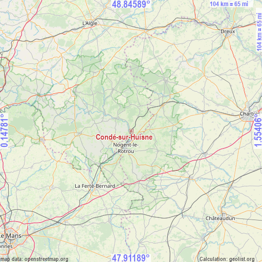
Condé-sur-Huisne GPS coordinates[2]
48° 22' 51.708" North, 0° 51' 3.348" East
| Map corner | latitude | longitude |
|---|---|---|
| Upper-left | 48.84589°, | 0.14781° |
| Center: | 48.38103°, | 0.85093° |
| Lower-right: | 47.91189°, | 1.55406° |
| Map W x H: | 103.9×103.8 km | = 64.6×64.5mi |
| max Lat: | 51.07786° ⇑34% North |
| Condé-sur-Huisne: | 48.38103° |
| min Lat: | ⇓66% South 41.3874° |
| min Long | Condé-sur-Huis | max Long |
| -5.08615° | 0.85093° | 9.52242° |
| W 29.8%⇐ | ⇒70.2% E |
Elevation
Elevation of Condé-sur-Huisne is 124 m = 407 ft, and this is 69.7 m = 229 ft below average elevation for this country.
| Max E: |
2333 m = 7654 ft | 52.3% |
| Avg. | 193.7 m = 635 ft | |
| Condé-sur-Huisne | 124 m = 407 ft | |
Min E: |
-1 m = -3 ft | 47.7% |
See also: France elevation on elevation.city.
Geographical zone
Condé-sur-Huisne is located in North temperate zone (between Tropic of Cancer and the Arctic Circle). Distance of this North polar circle is 2021.7 km =1256.2 mi to North.| Distance of | km | miles | from Condé-sur-Huisne |
|---|---|---|---|
| North Pole | 4627.6 | 2875.5 | to North |
| Arctic Circle | 2021.7 | 1256.2 | to North |
| Tropic Cancer | 2773.5 | 1723.4 | to South |
| Equator | 5379.5 | 3342.7 | to South |


Nearby cities:
15 places around Condé-sur-Huisne: (largest is in red/bold)
• Bretoncelles
6.2 km =3.9 mi,  25°
25°
• Brunelles
7.1 km =4.4 mi,  153°
153°
• La Loupe
15.9 km =9.9 mi,  49°
49°
• La Rouge
14.8 km =9.2 mi,  225°
225°
• Margon
5.2 km =3.2 mi,  193°
193°
• Moutiers-au-Perche
10.7 km =6.6 mi,  358°
358°
• Mâle
14.8 km =9.2 mi,  214°
214°
• Nocé
12.5 km =7.8 mi,  269°
269°
• Nogent-le-Rotrou
7 km =4.3 mi,  198°
198°
• Préaux-du-Perche
11.2 km =7 mi,  241°
241°
• Rémalard
7.9 km =4.9 mi,  312°
312°
• Saint-Hilaire-sur-Erre
11.2 km =7 mi, 227°
• Saint-Éliph
15 km =9.3 mi,  58°
58°
• Souancé-au-Perche
12.7 km =7.9 mi,  178°
178°
• Thiron Gardais
12.1 km =7.5 mi,  126°
126°
Sources, notices
• [Note1] Compared only with cities in France existing in our database
• [Src1] Map data: © OpenStreetMap contributors (CC-BY-SA)
• [Src2] Other city data from geonames.org with taken over terms of usage.
• [Src3] Geographical zone / Annual Mean Temperature by Robert A. Rohde @ Wikipedia
