Saint-Sulpice geodata
Saint-Sulpice (Hauts-de-France) is a populated place; located in France in Europe/Paris (GMT+2) time zone. With population of 1,144 people, there are 7863 cities with bigger population in this country. Compared to other cities in France, 87% of cities are located further ↓South; 55.5% of cities are located further →East and 59.7% of cities have higher elevation than Saint-Sulpice. Note1
Administrative division(s):
- Level 1: Hauts-de-France
- Level 2: Département de l'Oise
- Level 3: Arrondissement de Beauvais
- Level 4: Saint-Sulpice


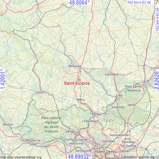
Saint-Sulpice GPS coordinates[2]
49° 21' 1.764" North, 2° 7' 23.304" East
| Map corner | latitude | longitude |
|---|---|---|
| Upper-left | 49.8064°, | 1.42001° |
| Center: | 49.35049°, | 2.12314° |
| Lower-right: | 48.89032°, | 2.82626° |
| Map W x H: | 101.9×101.9 km | = 63.3×63.3mi |
| max Lat: | 51.07786° ⇑13% North |
| Saint-Sulpice: | 49.35049° |
| min Lat: | ⇓87% South 41.3874° |
| min Long | Saint-Sulpice | max Long |
| -5.08615° | 2.12314° | 9.52242° |
| W 44.5%⇐ | ⇒55.5% E |
Elevation
Elevation of Saint-Sulpice is 103 m = 338 ft, and this is 90.7 m = 298 ft below average elevation for this country.
| Max E: |
2333 m = 7654 ft | 59.7% |
| Avg. | 193.7 m = 635 ft | |
| Saint-Sulpice | 103 m = 338 ft | |
Min E: |
-1 m = -3 ft | 40.3% |
See also: France elevation on elevation.city.
Geographical zone
Saint-Sulpice is located in North temperate zone (between Tropic of Cancer and the Arctic Circle). Distance of this North polar circle is 1913.9 km =1189.2 mi to North.| Distance of | km | miles | from Saint-Sulpice |
|---|---|---|---|
| North Pole | 4519.8 | 2808.5 | to North |
| Arctic Circle | 1913.9 | 1189.2 | to North |
| Tropic Cancer | 2881.3 | 1790.4 | to South |
| Equator | 5487.3 | 3409.6 | to South |


Nearby cities:
15 places around Saint-Sulpice: (largest is in red/bold)
• Allonne
6.5 km =4 mi,  354°
354°
• Auteuil
2.8 km =1.7 mi,  250°
250°
• Berneuil-en-Bray
4.1 km =2.5 mi,  269°
269°
• Berthecourt
7.4 km =4.6 mi,  89°
89°
• Frocourt
4.5 km =2.8 mi,  322°
322°
• Laboissière-en-Thelle
6.9 km =4.3 mi,  156°
156°
• Le Coudray-sur-Thelle
5 km =3.1 mi,  178°
178°
• Noailles
6.1 km =3.8 mi,  113°
113°
• Ponchon
5.4 km =3.4 mi, 94°
• Rochy-Condé
7.2 km =4.5 mi,  38°
38°
• Saint-Martin-le-Nœud
6.8 km =4.2 mi, 318°
• Therdonne
8 km =5 mi,  18°
18°
• Valdampierre
7.3 km =4.5 mi,  224°
224°
• Villers-Saint-Sépulcre
6.9 km =4.3 mi,  75°
75°
• Warluis
4.5 km =2.8 mi, 17°
Sources, notices
• [Note1] Compared only with cities in France existing in our database
• [Src1] Map data: © OpenStreetMap contributors (CC-BY-SA)
• [Src2] Other city data from geonames.org with taken over terms of usage.
• [Src3] Geographical zone / Annual Mean Temperature by Robert A. Rohde @ Wikipedia
