Neuvic geodata
Neuvic (Nouvelle-Aquitaine) is a populated place; located in France in Europe/Paris (GMT+2) time zone. With population of 2,325 people, there are 4153 cities with bigger population in this country. Compared to other cities in France, 75.5% of cities are located further ↑North; 53.2% of cities are located further →East and 95.4% of cities have lower elevation than Neuvic. Note1
Administrative division(s):
- Level 1: Nouvelle-Aquitaine
- Level 2: Département de la Corrèze
- Level 3: Ussel
- Level 4: Neuvic


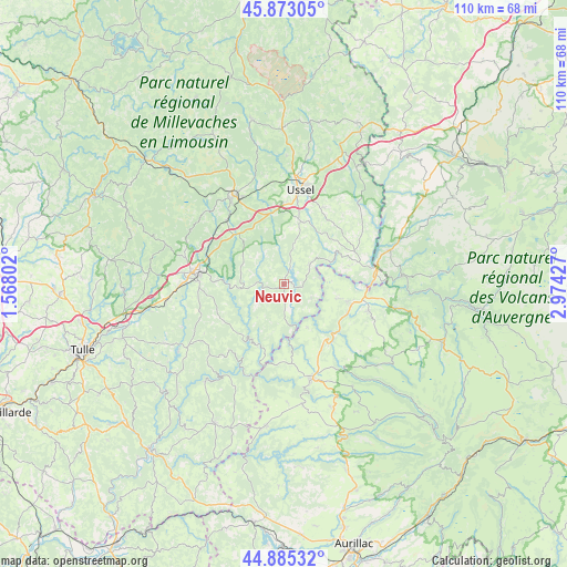
Neuvic GPS coordinates[2]
45° 22' 52.824" North, 2° 16' 16.14" East
| Map corner | latitude | longitude |
|---|---|---|
| Upper-left | 45.87305°, | 1.56802° |
| Center: | 45.38134°, | 2.27115° |
| Lower-right: | 44.88532°, | 2.97427° |
| Map W x H: | 109.8×109.8 km | = 68.2×68.2mi |
| max Lat: | 51.07786° ⇑75.5% North |
| Neuvic: | 45.38134° |
| min Lat: | ⇓24.5% South 41.3874° |
| min Long | Neuvic | max Long |
| -5.08615° | 2.27115° | 9.52242° |
| W 46.8%⇐ | ⇒53.2% E |
Elevation
Elevation of Neuvic is 610 m = 2001 ft, and this is 416.3 m = 1366 ft above average elevation for this country.
| Max E: |
2333 m = 7654 ft | 4.6% |
| Neuvic | 610 m 2001 ft | |
| Avg. | 193.7 m = 635 ft | |
Min E: |
-1 m = -3 ft | 95.4% |
See also: France elevation on elevation.city.
Geographical zone
Neuvic is located in North temperate zone (between Tropic of Cancer and the Arctic Circle). Distance of this North polar circle is 2355.2 km =1463.5 mi to North.| Distance of | km | miles | from Neuvic |
|---|---|---|---|
| North Pole | 4961.1 | 3082.7 | to North |
| Arctic Circle | 2355.2 | 1463.5 | to North |
| Tropic Cancer | 2440 | 1516.1 | to South |
| Equator | 5045.9 | 3135.4 | to South |


Nearby cities:
15 places around Neuvic: (largest is in red/bold)
• Bort-les-Orgues
17.7 km =11 mi,  83°
83°
• Champagnac
10.4 km =6.5 mi,  105°
105°
• La Feuillade
22.2 km =13.8 mi,  338°
338°
• Lanobre
21.5 km =13.4 mi,  72°
72°
• Le Vigean
18.3 km =11.4 mi,  159°
159°
• Mauriac
18.7 km =11.6 mi, 164°
• Meymac
19.7 km =12.2 mi,  330°
330°
• Saignes
17.1 km =10.6 mi, 107°
• Saint-Angel
13.9 km =8.6 mi,  347°
347°
• Saint-Exupéry-les-Roches
16.8 km =10.4 mi,  27°
27°
• Saint-Hippolyte
20.6 km =12.8 mi,  261°
261°
• Soursac
13 km =8.1 mi,  204°
204°
• Ussel
18.8 km =11.7 mi,  9°
9°
• Ydes
13.5 km =8.4 mi, 106°
• Égletons
17.9 km =11.1 mi,  278°
278°
Sources, notices
• [Note1] Compared only with cities in France existing in our database
• [Src1] Map data: © OpenStreetMap contributors (CC-BY-SA)
• [Src2] Other city data from geonames.org with taken over terms of usage.
• [Src3] Geographical zone / Annual Mean Temperature by Robert A. Rohde @ Wikipedia
