Luc-en-Diois geodata
Luc-en-Diois (Auvergne-Rhône-Alpes) is a populated place; located in France in Europe/Paris (GMT+2) time zone. With population of 537 people, there are 14448 cities with bigger population in this country. Compared to other cities in France, 82.7% of cities are located further ↑North; 82.5% of cities are located further ←West and 94.6% of cities have lower elevation than Luc-en-Diois. Note1
Administrative division(s):
- Level 1: Auvergne-Rhône-Alpes
- Level 2: Département de la Drôme
- Level 3: Arrondissement de Die
- Level 4: Luc-en-Diois


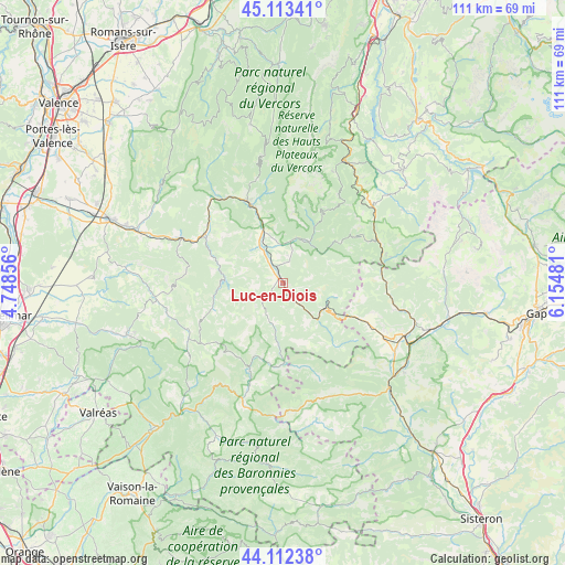
Luc-en-Diois GPS coordinates[2]
44° 36' 54.18" North, 5° 27' 6.048" East
| Map corner | latitude | longitude |
|---|---|---|
| Upper-left | 45.11341°, | 4.74856° |
| Center: | 44.61505°, | 5.45168° |
| Lower-right: | 44.11238°, | 6.15481° |
| Map W x H: | 111.3×111.3 km | = 69.2×69.2mi |
| max Lat: | 51.07786° ⇑82.7% North |
| Luc-en-Diois: | 44.61505° |
| min Lat: | ⇓17.3% South 41.3874° |
| min Long | Luc-en-Diois | max Long |
| -5.08615° | 5.45168° | 9.52242° |
| W 82.5%⇐ | ⇒17.5% E |
Elevation
Elevation of Luc-en-Diois is 563 m = 1847 ft, and this is 369.3 m = 1212 ft above average elevation for this country.
| Max E: |
2333 m = 7654 ft | 5.4% |
| Luc-en-Diois | 563 m 1847 ft | |
| Avg. | 193.7 m = 635 ft | |
Min E: |
-1 m = -3 ft | 94.6% |
See also: France elevation on elevation.city.
Geographical zone
Luc-en-Diois is located in North temperate zone (between Tropic of Cancer and the Arctic Circle). Distance of this Northern Tropic circle is 2354.8 km =1463.2 mi to South.| Distance of | km | miles | from Luc-en-Diois |
|---|---|---|---|
| North Pole | 5046.3 | 3135.6 | to North |
| Arctic Circle | 2440.4 | 1516.4 | to North |
| Tropic Cancer | 2354.8 | 1463.2 | to South |
| Equator | 4960.7 | 3082.4 | to South |


Nearby cities:
15 places around Luc-en-Diois: (largest is in red/bold)
• Aouste-sur-Sye
33.5 km =20.8 mi,  290°
290°
• Aspres-sur-Buëch
26 km =16.2 mi,  113°
113°
• Bourdeaux
25.2 km =15.7 mi,  262°
262°
• Châtillon-en-Diois
8.7 km =5.4 mi,  11°
11°
• Condorcet
30.5 km =19 mi,  220°
220°
• Die
16.7 km =10.4 mi,  337°
337°
• Dieulefit
32.4 km =20.1 mi,  252°
252°
• Mens
32.5 km =20.2 mi,  46°
46°
• Mirabel-et-Blacons
29.3 km =18.2 mi, 291°
• Piégros-la-Clastre
28.8 km =17.9 mi,  284°
284°
• Rosans
24.8 km =15.4 mi,  176°
176°
• Saillans
23.1 km =14.4 mi, 292°
• Saou
31 km =19.3 mi, 276°
• Serres
29.5 km =18.3 mi,  135°
135°
• Veynes
30.8 km =19.1 mi, 107°
Sources, notices
• [Note1] Compared only with cities in France existing in our database
• [Src1] Map data: © OpenStreetMap contributors (CC-BY-SA)
• [Src2] Other city data from geonames.org with taken over terms of usage.
• [Src3] Geographical zone / Annual Mean Temperature by Robert A. Rohde @ Wikipedia
