Veynes geodata
Veynes (Provence-Alpes-Côte d'Azur) is a populated place; located in France in Europe/Paris (GMT+2) time zone. With population of 3,230 people, there are 3024 cities with bigger population in this country. Compared to other cities in France, 83.3% of cities are located further ↑North; 85.3% of cities are located further ←West and 98.2% of cities have lower elevation than Veynes. Note1
Administrative division(s):
- Level 1: Provence-Alpes-Côte d'Azur
- Level 2: Hautes-Alpes
- Level 3: Arrondissement de Gap
- Level 4: Veynes


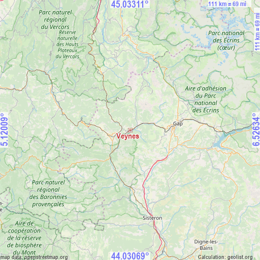
Veynes GPS coordinates[2]
44° 32' 2.616" North, 5° 49' 23.556" East
| Map corner | latitude | longitude |
|---|---|---|
| Upper-left | 45.03311°, | 5.12009° |
| Center: | 44.53406°, | 5.82321° |
| Lower-right: | 44.03069°, | 6.52634° |
| Map W x H: | 111.5×111.5 km | = 69.3×69.3mi |
| max Lat: | 51.07786° ⇑83.3% North |
| Veynes: | 44.53406° |
| min Lat: | ⇓16.7% South 41.3874° |
| min Long | Veynes | max Long |
| -5.08615° | 5.82321° | 9.52242° |
| W 85.3%⇐ | ⇒14.7% E |
Elevation
Elevation of Veynes is 846 m = 2776 ft, and this is 652.3 m = 2140 ft above average elevation for this country.
| Max E: |
2333 m = 7654 ft | 1.8% |
| Veynes | 846 m 2776 ft | |
| Avg. | 193.7 m = 635 ft | |
Min E: |
-1 m = -3 ft | 98.2% |
See also: France elevation on elevation.city.
Geographical zone
Veynes is located in North temperate zone (between Tropic of Cancer and the Arctic Circle). Distance of this Northern Tropic circle is 2345.8 km =1457.6 mi to South.| Distance of | km | miles | from Veynes |
|---|---|---|---|
| North Pole | 5055.3 | 3141.2 | to North |
| Arctic Circle | 2449.5 | 1522 | to North |
| Tropic Cancer | 2345.8 | 1457.6 | to South |
| Equator | 4951.7 | 3076.8 | to South |


Nearby cities:
15 places around Veynes: (largest is in red/bold)
• Aspres-sur-Buëch
5.7 km =3.5 mi,  256°
256°
• Gap
20.4 km =12.7 mi,  82°
82°
• La Bâtie-Neuve
29.8 km =18.5 mi, 82°
• La Motte-du-Caire
26.7 km =16.6 mi,  142°
142°
• La Roche-des-Arnauds
10.9 km =6.8 mi,  73°
73°
• La Saulce
18.9 km =11.7 mi,  129°
129°
• Laragne-Montéglin
24.2 km =15 mi,  181°
181°
• Le Dévoluy
20 km =12.4 mi,  27°
27°
• Mison
30 km =18.6 mi, 177°
• Neffes
16.1 km =10 mi,  101°
101°
• Saint-Bonnet-en-Champsaur
26.4 km =16.4 mi,  51°
51°
• Serres
14.6 km =9.1 mi,  216°
216°
• Sigoyer
13.6 km =8.5 mi,  117°
117°
• Tallard
19.8 km =12.3 mi,  113°
113°
• Ventavon
19.3 km =12 mi,  160°
160°
Sources, notices
• [Note1] Compared only with cities in France existing in our database
• [Src1] Map data: © OpenStreetMap contributors (CC-BY-SA)
• [Src2] Other city data from geonames.org with taken over terms of usage.
• [Src3] Geographical zone / Annual Mean Temperature by Robert A. Rohde @ Wikipedia
