Haguenau geodata
Haguenau (Grand Est) is a seat of a third-order administrative division; located in France in Europe/Paris (GMT+2) time zone. With population of 38,721 people, there are 193 cities with bigger population in this country. Compared to other cities in France, 75.9% of cities are located further ↓South; 99.2% of cities are located further ←West and 53.3% of cities have lower elevation than Haguenau. Note1
Administrative division(s):
- Level 1: Grand Est
- Level 2: Bas-Rhin
- Level 3: Arrondissement de Haguenau-Wissembourg
- Level 4: Haguenau


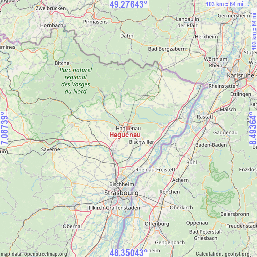
Haguenau GPS coordinates[2]
48° 48' 56.052" North, 7° 47' 25.836" East
| Map corner | latitude | longitude |
|---|---|---|
| Upper-left | 49.27643°, | 7.08739° |
| Center: | 48.81557°, | 7.79051° |
| Lower-right: | 48.35043°, | 8.49364° |
| Map W x H: | 103×103 km | = 64×64mi |
| max Lat: | 51.07786° ⇑24.1% North |
| Haguenau: | 48.81557° |
| min Lat: | ⇓75.9% South 41.3874° |
| min Long | Haguenau | max Long |
| -5.08615° | 7.79051° | 9.52242° |
| W 99.2%⇐ | ⇒0.8% E |
Elevation
Elevation of Haguenau is 144 m = 472 ft, and this is 49.7 m = 163 ft below average elevation for this country.
| Max E: |
2333 m = 7654 ft | 46.7% |
| Avg. | 193.7 m = 635 ft | |
| Haguenau | 144 m = 472 ft | |
Min E: |
-1 m = -3 ft | 53.3% |
See also: France elevation on elevation.city.
Geographical zone
Haguenau is located in North temperate zone (between Tropic of Cancer and the Arctic Circle). Distance of this North polar circle is 1973.4 km =1226.2 mi to North.| Distance of | km | miles | from Haguenau |
|---|---|---|---|
| North Pole | 4579.3 | 2845.4 | to North |
| Arctic Circle | 1973.4 | 1226.2 | to North |
| Tropic Cancer | 2821.9 | 1753.4 | to South |
| Equator | 5427.8 | 3372.7 | to South |


Nearby cities:
15 places around Haguenau: (largest is in red/bold)
• Batzendorf
7.1 km =4.4 mi,  239°
239°
• Bischwiller
7 km =4.3 mi,  138°
138°
• Eschbach
7.7 km =4.8 mi,  328°
328°
• Gries
7.1 km =4.4 mi,  165°
165°
• Kaltenhouse
4.1 km =2.5 mi,  131°
131°
• Kriegsheim
7.9 km =4.9 mi,  215°
215°
• Kurtzenhouse
8.5 km =5.3 mi, 173°
• Niederschaeffolsheim
6.1 km =3.8 mi, 218°
• Oberhoffen-sur-Moder
6.4 km =4 mi,  123°
123°
• Ohlungen
6.5 km =4 mi,  267°
267°
• Schirrhein
8.6 km =5.3 mi,  100°
100°
• Schweighouse-sur-Moder
4.6 km =2.9 mi,  276°
276°
• Walbourg
7.9 km =4.9 mi,  358°
358°
• Weitbruch
6.8 km =4.2 mi,  186°
186°
• Wintershouse
7.1 km =4.4 mi,  248°
248°
Sources, notices
• [Note1] Compared only with cities in France existing in our database
• [Src1] Map data: © OpenStreetMap contributors (CC-BY-SA)
• [Src2] Other city data from geonames.org with taken over terms of usage.
• [Src3] Geographical zone / Annual Mean Temperature by Robert A. Rohde @ Wikipedia
