Sigoyer geodata
Sigoyer (Provence-Alpes-Côte d'Azur) is a populated place; located in France in Europe/Paris (GMT+2) time zone. With population of 645 people, there are 12593 cities with bigger population in this country. Compared to other cities in France, 83.7% of cities are located further ↑North; 86.8% of cities are located further ←West and 99.1% of cities have lower elevation than Sigoyer. Note1
Administrative division(s):
- Level 1: Provence-Alpes-Côte d'Azur
- Level 2: Hautes-Alpes
- Level 3: Arrondissement de Gap
- Level 4: Sigoyer


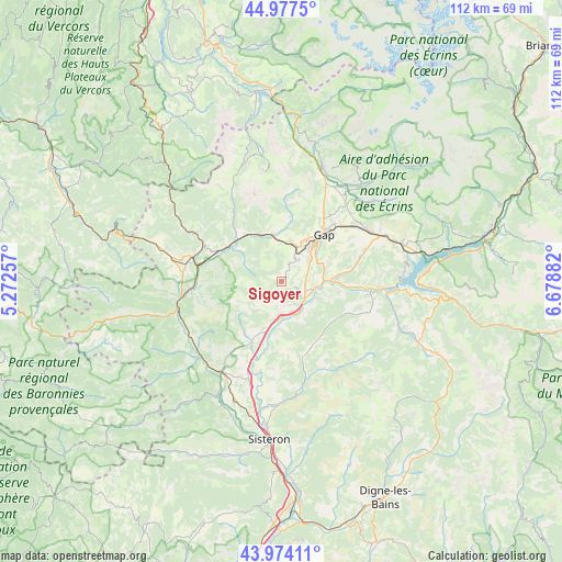
Sigoyer GPS coordinates[2]
44° 28' 40.656" North, 5° 58' 32.52" East
| Map corner | latitude | longitude |
|---|---|---|
| Upper-left | 44.9775°, | 5.27257° |
| Center: | 44.47796°, | 5.9757° |
| Lower-right: | 43.97411°, | 6.67882° |
| Map W x H: | 111.6×111.6 km | = 69.3×69.3mi |
| max Lat: | 51.07786° ⇑83.7% North |
| Sigoyer: | 44.47796° |
| min Lat: | ⇓16.3% South 41.3874° |
| min Long | Sigoyer | max Long |
| -5.08615° | 5.9757° | 9.52242° |
| W 86.8%⇐ | ⇒13.2% E |
Elevation
Elevation of Sigoyer is 1013 m = 3323 ft, and this is 819.3 m = 2688 ft above average elevation for this country.
| Max E: |
2333 m = 7654 ft | 0.90000000000001% |
| Sigoyer | 1013 m 3323 ft | |
| Avg. | 193.7 m = 635 ft | |
Min E: |
-1 m = -3 ft | 99.1% |
See also: France elevation on elevation.city.
Geographical zone
Sigoyer is located in North temperate zone (between Tropic of Cancer and the Arctic Circle). Distance of this Northern Tropic circle is 2339.6 km =1453.8 mi to South.| Distance of | km | miles | from Sigoyer |
|---|---|---|---|
| North Pole | 5061.6 | 3145.1 | to North |
| Arctic Circle | 2455.7 | 1525.9 | to North |
| Tropic Cancer | 2339.6 | 1453.8 | to South |
| Equator | 4945.5 | 3073 | to South |


Nearby cities:
15 places around Sigoyer: (largest is in red/bold)
• Aspres-sur-Buëch
18.4 km =11.4 mi,  285°
285°
• Espinasses
20.2 km =12.6 mi,  93°
93°
• Gap
12.1 km =7.5 mi,  42°
42°
• La Bâtie-Neuve
20.1 km =12.5 mi,  60°
60°
• La Motte-du-Caire
15.5 km =9.6 mi,  164°
164°
• La Roche-des-Arnauds
9.5 km =5.9 mi,  350°
350°
• La Saulce
6.3 km =3.9 mi, 157°
• Laragne-Montéglin
21.9 km =13.6 mi,  215°
215°
• Le Dévoluy
24.1 km =15 mi, 353°
• Neffes
4.7 km =2.9 mi,  50°
50°
• Saint-Bonnet-en-Champsaur
24.4 km =15.2 mi,  20°
20°
• Serres
21.5 km =13.4 mi,  254°
254°
• Tallard
6.3 km =3.9 mi,  106°
106°
• Ventavon
13.2 km =8.2 mi,  205°
205°
• Veynes
13.6 km =8.5 mi,  297°
297°
Sources, notices
• [Note1] Compared only with cities in France existing in our database
• [Src1] Map data: © OpenStreetMap contributors (CC-BY-SA)
• [Src2] Other city data from geonames.org with taken over terms of usage.
• [Src3] Geographical zone / Annual Mean Temperature by Robert A. Rohde @ Wikipedia
