Bénestroff geodata
Bénestroff (Grand Est) is a populated place; located in France in Europe/Paris (GMT+2) time zone. With population of 533 people, there are 14546 cities with bigger population in this country. Compared to other cities in France, 77.6% of cities are located further ↓South; 93.4% of cities are located further ←West and 75.1% of cities have lower elevation than Bénestroff. Note1
Administrative division(s):
- Level 1: Grand Est
- Level 2: Moselle
- Level 3: Arrondissement de Sarrebourg-Château-Salins
- Level 4: Bénestroff


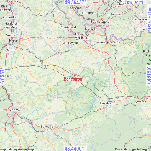
Bénestroff GPS coordinates[2]
48° 54' 15.588" North, 6° 45' 31.752" East
| Map corner | latitude | longitude |
|---|---|---|
| Upper-left | 49.36437°, | 6.0557° |
| Center: | 48.90433°, | 6.75882° |
| Lower-right: | 48.44001°, | 7.46195° |
| Map W x H: | 102.8×102.8 km | = 63.9×63.9mi |
| max Lat: | 51.07786° ⇑22.4% North |
| Bénestroff: | 48.90433° |
| min Lat: | ⇓77.6% South 41.3874° |
| min Long | Bénestroff | max Long |
| -5.08615° | 6.75882° | 9.52242° |
| W 93.4%⇐ | ⇒6.6% E |
Elevation
Elevation of Bénestroff is 250 m = 820 ft, and this is 56.3 m = 185 ft above average elevation for this country.
| Max E: |
2333 m = 7654 ft | 24.9% |
| Bénestroff | 250 m 820 ft | |
| Avg. | 193.7 m = 635 ft | |
Min E: |
-1 m = -3 ft | 75.1% |
See also: France elevation on elevation.city.
Geographical zone
Bénestroff is located in North temperate zone (between Tropic of Cancer and the Arctic Circle). Distance of this North polar circle is 1963.5 km =1220.1 mi to North.| Distance of | km | miles | from Bénestroff |
|---|---|---|---|
| North Pole | 4569.4 | 2839.3 | to North |
| Arctic Circle | 1963.5 | 1220.1 | to North |
| Tropic Cancer | 2831.7 | 1759.5 | to South |
| Equator | 5437.7 | 3378.8 | to South |


Nearby cities:
15 places around Bénestroff: (largest is in red/bold)
• Albestroff
7.8 km =4.8 mi,  65°
65°
• Dieuze
10.6 km =6.6 mi,  196°
196°
• Francaltroff
7 km =4.3 mi,  23°
23°
• Grostenquin
8.5 km =5.3 mi,  350°
350°
• Guessling-Hémering
15.3 km =9.5 mi,  331°
331°
• Hellimer
11.5 km =7.1 mi,  26°
26°
• Insming
10.3 km =6.4 mi,  56°
56°
• Laning
14.6 km =9.1 mi,  4°
4°
• Lixing-lès-Saint-Avold
14.7 km =9.1 mi,  358°
358°
• Mittersheim
14.2 km =8.8 mi,  109°
109°
• Morhange
8.8 km =5.5 mi,  284°
284°
• Racrange
6.9 km =4.3 mi,  289°
289°
• Saint-Jean-Rohrbach
16.4 km =10.2 mi, 34°
• Vahl-Ebersing
16.1 km =10 mi, 358°
• Vergaville
7.4 km =4.6 mi,  187°
187°
Sources, notices
• [Note1] Compared only with cities in France existing in our database
• [Src1] Map data: © OpenStreetMap contributors (CC-BY-SA)
• [Src2] Other city data from geonames.org with taken over terms of usage.
• [Src3] Geographical zone / Annual Mean Temperature by Robert A. Rohde @ Wikipedia
