Winneba geodata
Winneba (Central) is a populated place; located in Ghana in Africa/Accra (GMT+0) time zone. With population of 44,254 people, there are 32 cities with bigger population in this country. Compared to other cities in Ghana, 86.1% of cities are located further ↑North; 62.5% of cities are located further ←West and 84.7% of cities have higher elevation than Winneba. Note1


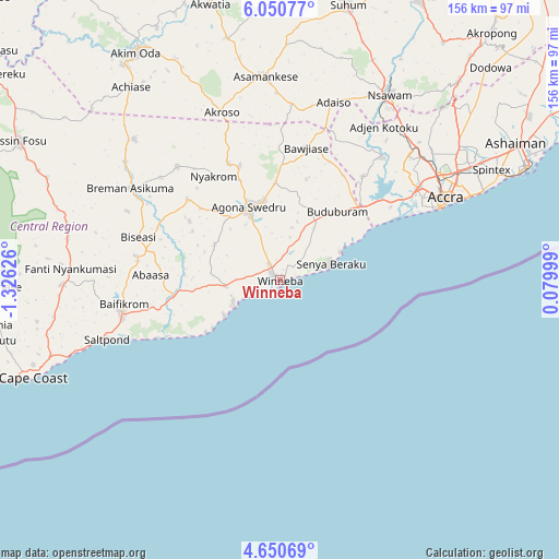
Winneba GPS coordinates[2]
5° 21' 4.068" North, 0° 37' 23.268" West
| Map corner | latitude | longitude |
|---|---|---|
| Upper-left | 6.05077°, | -1.32626° |
| Center: | 5.35113°, | -0.62313° |
| Lower-right: | 4.65069°, | 0.07999° |
| Map W x H: | 155.7×155.7 km | = 96.7×96.7mi |
| max Lat: | 11.0616° ⇑86.1% North |
| Winneba: | 5.35113° |
| min Lat: | ⇓13.9% South 4.86641° |
| min Long | Winneba | max Long |
| -2.78516° | -0.62313° | 1.19012° |
| W 62.5%⇐ | ⇒37.5% E |
Elevation
Elevation of Winneba is 25 m = 82 ft, and this is 145.2 m = 476 ft below average elevation for this country.
| Max E: |
477 m = 1565 ft | 84.7% |
| Avg. | 170.2 m = 558 ft | |
| Winneba | 25 m = 82 ft | |
Min E: |
0 m = 0 ft | 15.3% |
See also: Winneba elevation on elevation.city.
Geographical zone
Winneba is located in North Torrid zone (between Equator and Tropic of Cancer). Distance of Equator is 595 km =369.7 mi to South.| Distance of | km | miles | from Winneba |
|---|---|---|---|
| North Pole | 9412.1 | 5848.4 | to North |
| Arctic Circle | 6806.2 | 4229.2 | to North |
| Tropic Cancer | 2010.9 | 1249.5 | to North |
| Equator | 595 | 369.7 | to South |


Nearby cities:
15 places around Winneba: (largest is in red/bold)
• Accra
52.4 km =32.6 mi,  64°
64°
• Apam
14.6 km =9.1 mi,  239°
239°
• Asamankese
56.8 km =35.3 mi,  355°
355°
• Atsiaman
50.5 km =31.4 mi,  40°
40°
• Cape Coast
74.2 km =46.1 mi,  248°
248°
• Dome
54.2 km =33.7 mi,  52°
52°
• Gbawe
42.8 km =26.6 mi, 54°
• Kasoa
30.6 km =19 mi, 48°
• Medina Estates
61.8 km =38.4 mi, 55°
• Mumford
18 km =11.2 mi, 236°
• Nsawam
59.2 km =36.8 mi,  30°
30°
• Nungua
66.5 km =41.3 mi,  65°
65°
• Saltpond
50.9 km =31.6 mi, 251°
• Swedru
22.4 km =13.9 mi,  337°
337°
• Teshi Old Town
62.7 km =39 mi, 65°
Sources, notices
• [Note1] Compared only with cities in Ghana existing in our database
• [Src1] Map data: © OpenStreetMap contributors (CC-BY-SA)
• [Src2] Other city data from geonames.org with taken over terms of usage.
• [Src3] Geographical zone / Annual Mean Temperature by Robert A. Rohde @ Wikipedia
