Swedru geodata
Swedru (Central) is a populated place; located in Ghana in Africa/Accra (GMT+0) time zone. With population of 50,293 people, there are 26 cities with bigger population in this country. Compared to other cities in Ghana, 80.6% of cities are located further ↑North; 59.7% of cities are located further ←West and 66.7% of cities have higher elevation than Swedru. Note1


Swedru GPS coordinates[2]
5° 32' 13.596" North, 0° 41' 59.424" West
| Map corner | latitude | longitude |
|---|---|---|
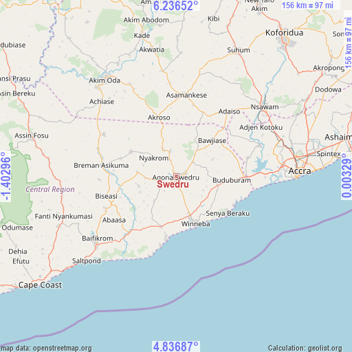
| Upper-left | 6.23652°, | -1.40296° |
| Center: | 5.53711°, | -0.69984° |
| Lower-right: | 4.83687°, | 0.00329° |
| Map W x H: | 155.6×155.6 km | = 96.7×96.7mi |
| max Lat: | 11.0616° ⇑80.6% North |
| Swedru: | 5.53711° |
| min Lat: | ⇓19.4% South 4.86641° |
| min Long | Swedru | max Long |
| -2.78516° | -0.69984° | 1.19012° |
| W 59.7%⇐ | ⇒40.3% E |
Elevation
Elevation of Swedru is 74 m = 243 ft, and this is 96.2 m = 316 ft below average elevation for this country.
| Max E: |
477 m = 1565 ft | 66.7% |
| Avg. | 170.2 m = 558 ft | |
| Swedru | 74 m = 243 ft | |
Min E: |
0 m = 0 ft | 33.3% |
See also: Swedru elevation on elevation.city.
Geographical zone
Swedru is located in North Torrid zone (between Equator and Tropic of Cancer). Distance of Equator is 615.7 km =382.6 mi to South.| Distance of | km | miles | from Swedru |
|---|---|---|---|
| North Pole | 9391.4 | 5835.5 | to North |
| Arctic Circle | 6785.5 | 4216.3 | to North |
| Tropic Cancer | 1990.3 | 1236.7 | to North |
| Equator | 615.7 | 382.6 | to South |


Nearby cities:
15 places around Swedru: (largest is in red/bold)
• Accra
55.7 km =34.6 mi,  87°
87°
• Akim Oda
53.6 km =33.3 mi,  323°
323°
• Akim Swedru
52.9 km =32.9 mi, 318°
• Akwatia
57.2 km =35.5 mi,  347°
347°
• Apam
28.4 km =17.6 mi,  188°
188°
• Asamankese
36.1 km =22.4 mi,  6°
6°
• Atsiaman
44.8 km =27.8 mi,  66°
66°
• Dome
52.8 km =32.8 mi,  76°
76°
• Gbawe
43.3 km =26.9 mi, 84°
• Kasoa
31.3 km =19.4 mi, 90°
• Medina Estates
61.1 km =38 mi, 76°
• Mumford
31.3 km =19.4 mi, 192°
• Nsawam
49.1 km =30.5 mi,  51°
51°
• Saltpond
54.1 km =33.6 mi,  227°
227°
• Winneba
22.4 km =13.9 mi,  157°
157°
Sources, notices
• [Note1] Compared only with cities in Ghana existing in our database
• [Src1] Map data: © OpenStreetMap contributors (CC-BY-SA)
• [Src2] Other city data from geonames.org with taken over terms of usage.
• [Src3] Geographical zone / Annual Mean Temperature by Robert A. Rohde @ Wikipedia
