Begoro geodata
Begoro (Eastern) is a populated place; located in Ghana in Africa/Accra (GMT+0) time zone. With population of 29,516 people, there are 44 cities with bigger population in this country. Compared to other cities in Ghana, 55.6% of cities are located further ↓South; 69.4% of cities are located further ←West and 98.6% of cities have lower elevation than Begoro. Note1


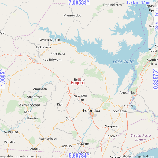
Begoro GPS coordinates[2]
6° 23' 13.416" North, 0° 22' 38.568" West
| Map corner | latitude | longitude |
|---|---|---|
| Upper-left | 7.08533°, | -1.0805° |
| Center: | 6.38706°, | -0.37738° |
| Lower-right: | 5.68784°, | 0.32575° |
| Map W x H: | 155.4×155.4 km | = 96.6×96.6mi |
| max Lat: | 11.0616° ⇑44.4% North |
| Begoro: | 6.38706° |
| min Lat: | ⇓55.6% South 4.86641° |
| min Long | Begoro | max Long |
| -2.78516° | -0.37738° | 1.19012° |
| W 69.4%⇐ | ⇒30.6% E |
Elevation
Elevation of Begoro is 460 m = 1509 ft, and this is 289.8 m = 951 ft above average elevation for this country.
| Max E: |
477 m = 1565 ft | 1.4% |
| Begoro | 460 m 1509 ft | |
| Avg. | 170.2 m = 558 ft | |
Min E: |
0 m = 0 ft | 98.6% |
See also: Ghana elevation on elevation.city.
Geographical zone
Begoro is located in North Torrid zone (between Equator and Tropic of Cancer). Distance of Equator is 710.2 km =441.3 mi to South.| Distance of | km | miles | from Begoro |
|---|---|---|---|
| North Pole | 9296.9 | 5776.8 | to North |
| Arctic Circle | 6691 | 4157.6 | to North |
| Tropic Cancer | 1895.7 | 1177.9 | to North |
| Equator | 710.2 | 441.3 | to South |


Nearby cities:
15 places around Begoro: (largest is in red/bold)
• Aburi
64 km =39.8 mi,  159°
159°
• Akim Oda
84.5 km =52.5 mi,  232°
232°
• Akropong
56.1 km =34.9 mi,  144°
144°
• Akwatia
61.3 km =38.1 mi, 231°
• Asamankese
66.6 km =41.4 mi,  208°
208°
• Atsiaman
76.8 km =47.7 mi,  175°
175°
• Dome
83.4 km =51.8 mi,  169°
169°
• Kibi
31.5 km =19.6 mi,  218°
218°
• Koforidua
35.1 km =21.8 mi, 158°
• Medina Estates
83.6 km =51.9 mi, 163°
• Mpraeso
45.6 km =28.3 mi,  300°
300°
• Nsawam
64.4 km =40 mi, 177°
• Odumase Krobo
51.2 km =31.8 mi,  288°
288°
• Suhum
39.3 km =24.4 mi,  191°
191°
• Tema
89.2 km =55.4 mi,  153°
153°
Sources, notices
• [Note1] Compared only with cities in Ghana existing in our database
• [Src1] Map data: © OpenStreetMap contributors (CC-BY-SA)
• [Src2] Other city data from geonames.org with taken over terms of usage.
• [Src3] Geographical zone / Annual Mean Temperature by Robert A. Rohde @ Wikipedia
