Kete Krachi geodata
Kete Krachi (Volta) is a seat of a second-order administrative division; located in Ghana in Africa/Accra (GMT+0) time zone. With population of 11,000 people, there are 63 cities with bigger population in this country. Compared to other cities in Ghana, 86.1% of cities are located further ↓South; 87.5% of cities are located further ←West and 61.1% of cities have higher elevation than Kete Krachi. Note1


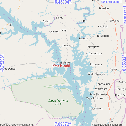
Kete Krachi GPS coordinates[2]
7° 47' 38.076" North, 0° 2' 59.28" West
| Map corner | latitude | longitude |
|---|---|---|
| Upper-left | 8.48994°, | -0.75293° |
| Center: | 7.79391°, | -0.0498° |
| Lower-right: | 7.09672°, | 0.65332° |
| Map W x H: | 154.9×154.9 km | = 96.3×96.3mi |
| max Lat: | 11.0616° ⇑13.9% North |
| Kete Krachi: | 7.79391° |
| min Lat: | ⇓86.1% South 4.86641° |
| min Long | Kete Krachi | max Long |
| -2.78516° | -0.0498° | 1.19012° |
| W 87.5%⇐ | ⇒12.5% E |
Elevation
Elevation of Kete Krachi is 117 m = 384 ft, and this is 53.2 m = 175 ft below average elevation for this country.
| Max E: |
477 m = 1565 ft | 61.1% |
| Avg. | 170.2 m = 558 ft | |
| Kete Krachi | 117 m = 384 ft | |
Min E: |
0 m = 0 ft | 38.9% |
See also: Ghana elevation on elevation.city.
Geographical zone
Kete Krachi is located in North Torrid zone (between Equator and Tropic of Cancer). Distance of Equator is 866.6 km =538.5 mi to South.| Distance of | km | miles | from Kete Krachi |
|---|---|---|---|
| North Pole | 9140.5 | 5679.6 | to North |
| Arctic Circle | 6534.6 | 4060.4 | to North |
| Tropic Cancer | 1739.3 | 1080.8 | to North |
| Equator | 866.6 | 538.5 | to South |


Nearby cities:
15 places around Kete Krachi: (largest is in red/bold)
• Agogo
158.6 km =98.5 mi,  225°
225°
• Begoro
160.5 km =99.7 mi,  193°
193°
• Ejura
151 km =93.8 mi,  252°
252°
• Ho
144.6 km =89.9 mi,  156°
156°
• Hohoe
91.8 km =57 mi,  141°
141°
• Kibi
189.5 km =117.7 mi,  197°
197°
• Kintampo
187.4 km =116.4 mi,  278°
278°
• Konongo
183.6 km =114.1 mi,  224°
224°
• Kpandae
75.2 km =46.7 mi,  3°
3°
• Kpandu
96.5 km =60 mi, 156°
• Mampong
169.6 km =105.4 mi,  241°
241°
• Mpraeso
153.4 km =95.3 mi,  209°
209°
• Odumase Krobo
163.7 km =101.7 mi, 211°
• Salaga
98.7 km =61.3 mi,  328°
328°
• Yendi
183.4 km =114 mi, 1°
Sources, notices
• [Note1] Compared only with cities in Ghana existing in our database
• [Src1] Map data: © OpenStreetMap contributors (CC-BY-SA)
• [Src2] Other city data from geonames.org with taken over terms of usage.
• [Src3] Geographical zone / Annual Mean Temperature by Robert A. Rohde @ Wikipedia
