Ejura geodata
Ejura (Ashanti) is a populated place; located in Ghana in Africa/Accra (GMT+0) time zone. With population of 70,807 people, there are 14 cities with bigger population in this country. Compared to other cities in Ghana, 79.2% of cities are located further ↓South; 65.3% of cities are located further →East and 68.1% of cities have lower elevation than Ejura. Note1


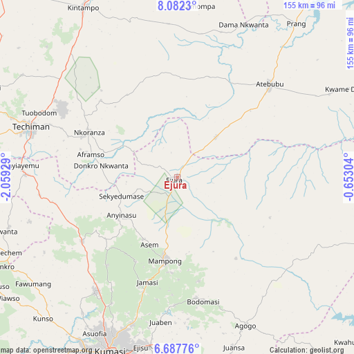
Ejura GPS coordinates[2]
7° 23' 8.088" North, 1° 21' 22.212" West
| Map corner | latitude | longitude |
|---|---|---|
| Upper-left | 8.0823°, | -2.05929° |
| Center: | 7.38558°, | -1.35617° |
| Lower-right: | 6.68776°, | -0.65304° |
| Map W x H: | 155.1×155.1 km | = 96.4×96.4mi |
| max Lat: | 11.0616° ⇑20.8% North |
| Ejura: | 7.38558° |
| min Lat: | ⇓79.2% South 4.86641° |
| min Long | Ejura | max Long |
| -2.78516° | -1.35617° | 1.19012° |
| W 34.7%⇐ | ⇒65.3% E |
Elevation
Elevation of Ejura is 224 m = 735 ft, and this is 53.8 m = 177 ft above average elevation for this country.
| Max E: |
477 m = 1565 ft | 31.9% |
| Ejura | 224 m 735 ft | |
| Avg. | 170.2 m = 558 ft | |
Min E: |
0 m = 0 ft | 68.1% |
See also: Ejura elevation on elevation.city.
Geographical zone
Ejura is located in North Torrid zone (between Equator and Tropic of Cancer). Distance of Equator is 821.2 km =510.3 mi to South.| Distance of | km | miles | from Ejura |
|---|---|---|---|
| North Pole | 9185.9 | 5707.9 | to North |
| Arctic Circle | 6580 | 4088.6 | to North |
| Tropic Cancer | 1784.7 | 1109 | to North |
| Equator | 821.2 | 510.3 | to South |


Nearby cities:
15 places around Ejura: (largest is in red/bold)
• Agogo
71.8 km =44.6 mi,  155°
155°
• Bechem
80.7 km =50.1 mi,  246°
246°
• Bekwai
106.7 km =66.3 mi,  193°
193°
• Duayaw-Nkwanta
85.3 km =53 mi, 254°
• Kintampo
85.2 km =52.9 mi,  331°
331°
• Konongo
86.9 km =54 mi,  169°
169°
• Kumasi
83 km =51.6 mi,  200°
200°
• Mampong
36.2 km =22.5 mi, 187°
• Mamponteng
75.6 km =47 mi, 196°
• Mpraeso
111.7 km =69.4 mi,  142°
142°
• Odumase Krobo
111.9 km =69.5 mi,  147°
147°
• Sunyani
107.2 km =66.6 mi,  267°
267°
• Tafo
78.1 km =48.5 mi, 201°
• Techiman
67.9 km =42.2 mi,  288°
288°
• Wenchi
91.4 km =56.8 mi,  295°
295°
Sources, notices
• [Note1] Compared only with cities in Ghana existing in our database
• [Src1] Map data: © OpenStreetMap contributors (CC-BY-SA)
• [Src2] Other city data from geonames.org with taken over terms of usage.
• [Src3] Geographical zone / Annual Mean Temperature by Robert A. Rohde @ Wikipedia
