Odumase Krobo geodata
Odumase Krobo (Eastern) is a seat of a second-order administrative division; located in Ghana in Africa/Accra (GMT+0) time zone. In our database, there are 70 cities with bigger population. Compared to other cities in Ghana, 59.7% of cities are located further ↓South; 52.8% of cities are located further ←West and 65.3% of cities have lower elevation than Odumase Krobo. Note1


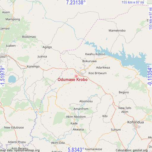
Odumase Krobo GPS coordinates[2]
6° 31' 59.988" North, 0° 49' 0.012" West
| Map corner | latitude | longitude |
|---|---|---|
| Upper-left | 7.23138°, | -1.51979° |
| Center: | 6.53333°, | -0.81667° |
| Lower-right: | 5.8343°, | -0.11354° |
| Map W x H: | 155.3×155.3 km | = 96.5×96.5mi |
| max Lat: | 11.0616° ⇑40.3% North |
| Odumase Krobo: | 6.53333° |
| min Lat: | ⇓59.7% South 4.86641° |
| min Long | Odumase Krobo | max Long |
| -2.78516° | -0.81667° | 1.19012° |
| W 52.8%⇐ | ⇒47.2% E |
Elevation
Elevation of Odumase Krobo is 214 m = 702 ft, and this is 43.8 m = 144 ft above average elevation for this country.
| Max E: |
477 m = 1565 ft | 34.7% |
| Odumase Krobo | 214 m 702 ft | |
| Avg. | 170.2 m = 558 ft | |
Min E: |
0 m = 0 ft | 65.3% |
See also: Ghana elevation on elevation.city.
Geographical zone
Odumase Krobo is located in North Torrid zone (between Equator and Tropic of Cancer). Distance of Equator is 726.4 km =451.4 mi to South.| Distance of | km | miles | from Odumase Krobo |
|---|---|---|---|
| North Pole | 9280.6 | 5766.7 | to North |
| Arctic Circle | 6674.7 | 4147.5 | to North |
| Tropic Cancer | 1879.5 | 1167.9 | to North |
| Equator | 726.4 | 451.4 | to South |


Nearby cities:
15 places around Odumase Krobo: (largest is in red/bold)
• Agogo
41.7 km =25.9 mi,  315°
315°
• Akim Oda
70 km =43.5 mi,  195°
195°
• Akim Swedru
74.5 km =46.3 mi, 197°
• Akwatia
54.8 km =34.1 mi,  179°
179°
• Asamankese
76.8 km =47.7 mi,  167°
167°
• Begoro
51.2 km =31.8 mi,  108°
108°
• Bekwai
84.7 km =52.6 mi,  263°
263°
• Kibi
50.2 km =31.2 mi,  144°
144°
• Koforidua
78.6 km =48.8 mi,  128°
128°
• Konongo
45.1 km =28 mi,  281°
281°
• Mampong
87.3 km =54.2 mi,  312°
312°
• Mamponteng
84 km =52.2 mi,  285°
285°
• Mpraeso
11.2 km =7 mi,  53°
53°
• Suhum
68.1 km =42.3 mi, 143°
• Tafo
90.7 km =56.4 mi, 284°
Sources, notices
• [Note1] Compared only with cities in Ghana existing in our database
• [Src1] Map data: © OpenStreetMap contributors (CC-BY-SA)
• [Src2] Other city data from geonames.org with taken over terms of usage.
• [Src3] Geographical zone / Annual Mean Temperature by Robert A. Rohde @ Wikipedia
