Ho geodata
Ho (Volta) is a seat of a first-order administrative division; located in Ghana in Africa/Accra (GMT+0) time zone. With population of 69,998 people, there are 17 cities with bigger population in this country. Compared to other cities in Ghana, 62.5% of cities are located further ↓South; 94.4% of cities are located further ←West and 52.8% of cities have lower elevation than Ho. Note1


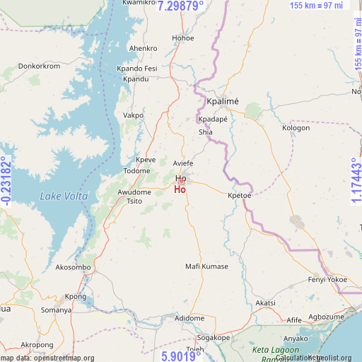
Ho GPS coordinates[2]
6° 36' 3.024" North, 0° 28' 16.68" East
| Map corner | latitude | longitude |
|---|---|---|
| Upper-left | 7.29879°, | -0.23182° |
| Center: | 6.60084°, | 0.4713° |
| Lower-right: | 5.9019°, | 1.17443° |
| Map W x H: | 155.3×155.3 km | = 96.5×96.5mi |
| max Lat: | 11.0616° ⇑37.5% North |
| Ho: | 6.60084° |
| min Lat: | ⇓62.5% South 4.86641° |
| min Long | Ho | max Long |
| -2.78516° | 0.4713° | 1.19012° |
| W 94.4%⇐ | ⇒5.6% E |
Elevation
Elevation of Ho is 171 m = 561 ft, and this is 0.80000000000001 m = 3 ft above average elevation for this country.
| Max E: |
477 m = 1565 ft | 47.2% |
| Ho | 171 m 561 ft | |
| Avg. | 170.2 m = 558 ft | |
Min E: |
0 m = 0 ft | 52.8% |
See also: Ho elevation on elevation.city.
Geographical zone
Ho is located in North Torrid zone (between Equator and Tropic of Cancer). Distance of Equator is 733.9 km =456 mi to South.| Distance of | km | miles | from Ho |
|---|---|---|---|
| North Pole | 9273.1 | 5762 | to North |
| Arctic Circle | 6667.2 | 4142.8 | to North |
| Tropic Cancer | 1872 | 1163.2 | to North |
| Equator | 733.9 | 456 | to South |


Nearby cities:
15 places around Ho: (largest is in red/bold)
• Aburi
110 km =68.4 mi,  220°
220°
• Aflao
95.8 km =59.5 mi,  123°
123°
• Akropong
92.9 km =57.7 mi, 221°
• Anloga
101.2 km =62.9 mi,  152°
152°
• Begoro
96.7 km =60.1 mi,  255°
255°
• Hohoe
61.3 km =38.1 mi,  0°
0°
• Keta
95 km =59 mi,  143°
143°
• Kibi
123.2 km =76.6 mi,  246°
246°
• Koforidua
98.4 km =61.1 mi,  235°
235°
• Kpandu
48.1 km =29.9 mi,  335°
335°
• Medina Estates
125.4 km =77.9 mi,  214°
214°
• Nsawam
126.5 km =78.6 mi,  225°
225°
• Nungua
126.6 km =78.7 mi, 208°
• Suhum
119.3 km =74.1 mi, 238°
• Tema
116.7 km =72.5 mi, 207°
Sources, notices
• [Note1] Compared only with cities in Ghana existing in our database
• [Src1] Map data: © OpenStreetMap contributors (CC-BY-SA)
• [Src2] Other city data from geonames.org with taken over terms of usage.
• [Src3] Geographical zone / Annual Mean Temperature by Robert A. Rohde @ Wikipedia
