Kintampo geodata
Kintampo (Brong-Ahafo) is a populated place; located in Ghana in Africa/Accra (GMT+0) time zone. With population of 47,185 people, there are 29 cities with bigger population in this country. Compared to other cities in Ghana, 87.5% of cities are located further ↓South; 76.4% of cities are located further →East and 90.3% of cities have lower elevation than Kintampo. Note1


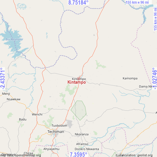
Kintampo GPS coordinates[2]
8° 3' 22.572" North, 1° 43' 50.088" West
| Map corner | latitude | longitude |
|---|---|---|
| Upper-left | 8.75184°, | -2.43371° |
| Center: | 8.05627°, | -1.73058° |
| Lower-right: | 7.3595°, | -1.02746° |
| Map W x H: | 154.8×154.8 km | = 96.2×96.2mi |
| max Lat: | 11.0616° ⇑12.5% North |
| Kintampo: | 8.05627° |
| min Lat: | ⇓87.5% South 4.86641° |
| min Long | Kintampo | max Long |
| -2.78516° | -1.73058° | 1.19012° |
| W 23.6%⇐ | ⇒76.4% E |
Elevation
Elevation of Kintampo is 343 m = 1125 ft, and this is 172.8 m = 567 ft above average elevation for this country.
| Max E: |
477 m = 1565 ft | 9.7% |
| Kintampo | 343 m 1125 ft | |
| Avg. | 170.2 m = 558 ft | |
Min E: |
0 m = 0 ft | 90.3% |
See also: Kintampo elevation on elevation.city.
Geographical zone
Kintampo is located in North Torrid zone (between Equator and Tropic of Cancer). Distance of Equator is 895.8 km =556.6 mi to South.| Distance of | km | miles | from Kintampo |
|---|---|---|---|
| North Pole | 9111.3 | 5661.5 | to North |
| Arctic Circle | 6505.4 | 4042.3 | to North |
| Tropic Cancer | 1710.1 | 1062.6 | to North |
| Equator | 895.8 | 556.6 | to South |


Nearby cities:
15 places around Kintampo: (largest is in red/bold)
• Agogo
156.9 km =97.5 mi,  152°
152°
• Bechem
112.2 km =69.7 mi,  196°
196°
• Berekum
115.5 km =71.8 mi,  234°
234°
• Duayaw-Nkwanta
106.1 km =65.9 mi, 202°
• Ejura
85.2 km =52.9 mi, 151°
• Japekrom
127.9 km =79.5 mi,  245°
245°
• Konongo
169.8 km =105.5 mi,  160°
160°
• Kumasi
152.5 km =94.8 mi,  175°
175°
• Mampong
116.3 km =72.3 mi, 161°
• Mamponteng
148.4 km =92.2 mi,  172°
172°
• Salaga
144.2 km =89.6 mi,  67°
67°
• Sunyani
103.2 km =64.1 mi,  219°
219°
• Tafo
147.9 km =91.9 mi, 174°
• Techiman
57.3 km =35.6 mi, 203°
• Wenchi
54.2 km =33.7 mi, 229°
Sources, notices
• [Note1] Compared only with cities in Ghana existing in our database
• [Src1] Map data: © OpenStreetMap contributors (CC-BY-SA)
• [Src2] Other city data from geonames.org with taken over terms of usage.
• [Src3] Geographical zone / Annual Mean Temperature by Robert A. Rohde @ Wikipedia
