Kpandae geodata
Kpandae (Northern) is a seat of a second-order administrative division; located in Ghana in Africa/Accra (GMT+0) time zone. With population of 8,652 people, there are 68 cities with bigger population in this country. Compared to other cities in Ghana, 88.9% of cities are located further ↓South; 90.3% of cities are located further ←West and 58.3% of cities have lower elevation than Kpandae. Note1


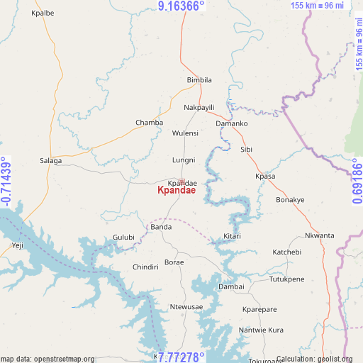
Kpandae GPS coordinates[2]
8° 28' 7.86" North, 0° 0' 40.572" West
| Map corner | latitude | longitude |
|---|---|---|
| Upper-left | 9.16366°, | -0.71439° |
| Center: | 8.46885°, | -0.01127° |
| Lower-right: | 7.77278°, | 0.69186° |
| Map W x H: | 154.7×154.7 km | = 96.1×96.1mi |
| max Lat: | 11.0616° ⇑11.1% North |
| Kpandae: | 8.46885° |
| min Lat: | ⇓88.9% South 4.86641° |
| min Long | Kpandae | max Long |
| -2.78516° | -0.01127° | 1.19012° |
| W 90.3%⇐ | ⇒9.7% E |
Elevation
Elevation of Kpandae is 183 m = 600 ft, and this is 12.8 m = 42 ft above average elevation for this country.
| Max E: |
477 m = 1565 ft | 41.7% |
| Kpandae | 183 m 600 ft | |
| Avg. | 170.2 m = 558 ft | |
Min E: |
0 m = 0 ft | 58.3% |
See also: Ghana elevation on elevation.city.
Geographical zone
Kpandae is located in North Torrid zone (between Equator and Tropic of Cancer). Distance of Equator is 941.6 km =585.1 mi to South.| Distance of | km | miles | from Kpandae |
|---|---|---|---|
| North Pole | 9065.4 | 5633 | to North |
| Arctic Circle | 6459.5 | 4013.7 | to North |
| Tropic Cancer | 1664.3 | 1034.1 | to North |
| Equator | 941.6 | 585.1 | to South |


Nearby cities:
15 places around Kpandae: (largest is in red/bold)
• Agogo
219.9 km =136.6 mi,  212°
212°
• Ejura
190.9 km =118.6 mi,  230°
230°
• Ho
214.4 km =133.2 mi,  165°
165°
• Hohoe
155.9 km =96.9 mi,  159°
159°
• Kete Krachi
75.2 km =46.7 mi,  183°
183°
• Kintampo
194.7 km =121 mi,  256°
256°
• Kpandu
167.2 km =103.9 mi, 168°
• Mampong
218.8 km =136 mi,  224°
224°
• Mpraeso
223.3 km =138.8 mi,  200°
200°
• Odumase Krobo
232.8 km =144.7 mi, 202°
• Salaga
56.5 km =35.1 mi,  279°
279°
• Savelugu
156.5 km =97.2 mi,  325°
325°
• Tamale
137.9 km =85.7 mi,  318°
318°
• Techiman
233.8 km =145.3 mi,  245°
245°
• Yendi
108.3 km =67.3 mi,  0°
0°
Sources, notices
• [Note1] Compared only with cities in Ghana existing in our database
• [Src1] Map data: © OpenStreetMap contributors (CC-BY-SA)
• [Src2] Other city data from geonames.org with taken over terms of usage.
• [Src3] Geographical zone / Annual Mean Temperature by Robert A. Rohde @ Wikipedia
