Malabo geodata
Malabo (Bioko Norte) is a capital of a political entity; located in Equatorial Guinea in Africa/Malabo (GMT+1) time zone. With population of 155,963 people, there is 1 city with bigger population in this country. Compared to other cities in Equatorial Guinea, 100% of cities are located further ↓South; 83.3% of cities are located further →East and 66.7% of cities have higher elevation than Malabo. Note1


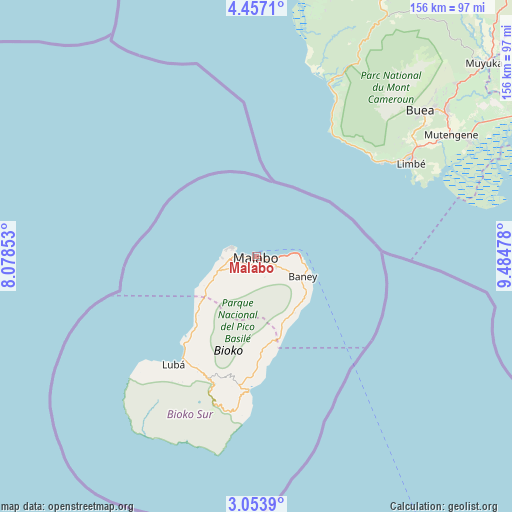
Malabo GPS coordinates[2]
3° 45' 20.808" North, 8° 46' 53.976" East
| Map corner | latitude | longitude |
|---|---|---|
| Upper-left | 4.4571°, | 8.07853° |
| Center: | 3.75578°, | 8.78166° |
| Lower-right: | 3.0539°, | 9.48478° |
| Map W x H: | 156×156 km | = 96.9×96.9mi |
| max Lat: | 3.75578° ⇑0% North |
| Malabo: | 3.75578° |
| min Lat: | ⇓100% South -1.4068° |
| min Long | Malabo | max Long |
| 5.63178° | 8.78166° | 11.33528° |
| W 16.7%⇐ | ⇒83.3% E |
Elevation
Elevation of Malabo is 106 m = 348 ft, and this is 266 m = 873 ft below average elevation for this country.
| Max E: |
1278 m = 4193 ft | 66.7% |
| Avg. | 372 m = 1220 ft | |
| Malabo | 106 m = 348 ft | |
Min E: |
4 m = 13 ft | 33.3% |
See also: Malabo elevation on elevation.city.
Geographical zone
Malabo is located in North Torrid zone (between Equator and Tropic of Cancer). Distance of Equator is 417.6 km =259.5 mi to South.| Distance of | km | miles | from Malabo |
|---|---|---|---|
| North Pole | 9589.5 | 5958.6 | to North |
| Arctic Circle | 6983.6 | 4339.4 | to North |
| Tropic Cancer | 2188.3 | 1359.7 | to North |
| Equator | 417.6 | 259.5 | to South |


Nearby cities:
15 places around Malabo: (largest is in red/bold)
• Ayene
299.2 km =185.9 mi,  134°
134°
• Añisoc
304.7 km =189.3 mi, 133°
• Bata
237.1 km =147.3 mi,  152°
152°
• Bicurga
305.8 km =190 mi,  142°
142°
• Bitica
275.4 km =171.1 mi,  160°
160°
• Ciudad de Riaba
41.5 km =25.8 mi,  182°
182°
• Luba
41.7 km =25.9 mi,  217°
217°
• Machinda
245.5 km =152.5 mi, 148°
• Mbini
258.7 km =160.7 mi, 159°
• Mikomeseng
271.7 km =168.8 mi, 131°
• Moca
48.7 km =30.3 mi,  195°
195°
• Ncue
269.4 km =167.4 mi, 135°
• Rebola
7.2 km =4.5 mi, 127°
• Río Campo
195.4 km =121.4 mi, 143°
• Santiago de Baney
15.4 km =9.6 mi,  114°
114°
In other languages:
- In Spanish: Ciudad de Malabo, Santa Isabel, Malabo
- In Russian: Малабо
- In Chinese: 馬拉博
Sources, notices
• [Note1] Compared only with cities in Equatorial Guinea existing in our database
• [Src1] Map data: © OpenStreetMap contributors (CC-BY-SA)
• [Src2] Other city data from geonames.org with taken over terms of usage.
• [Src3] Geographical zone / Annual Mean Temperature by Robert A. Rohde @ Wikipedia
