Mbini geodata
Mbini (Litoral) is a populated place; located in Equatorial Guinea in Africa/Malabo (GMT+1) time zone. With population of 4,062 people, there are 12 cities with bigger population in this country. Compared to other cities in Equatorial Guinea, 66.7% of cities are located further ↑North; 70.8% of cities are located further →East and 95.8% of cities have higher elevation than Mbini. Note1


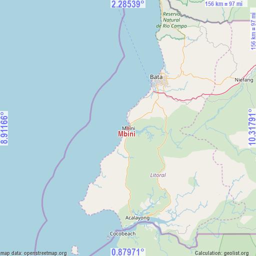
Mbini GPS coordinates[2]
1° 34' 57.612" North, 9° 36' 53.208" East
| Map corner | latitude | longitude |
|---|---|---|
| Upper-left | 2.28539°, | 8.91166° |
| Center: | 1.58267°, | 9.61478° |
| Lower-right: | 0.87971°, | 10.31791° |
| Map W x H: | 156.3×156.3 km | = 97.1×97.1mi |
| max Lat: | 3.75578° ⇑66.7% North |
| Mbini: | 1.58267° |
| min Lat: | ⇓33.3% South -1.4068° |
| min Long | Mbini | max Long |
| 5.63178° | 9.61478° | 11.33528° |
| W 29.2%⇐ | ⇒70.8% E |
Elevation
Elevation of Mbini is 13 m = 43 ft, and this is 359 m = 1178 ft below average elevation for this country.
| Max E: |
1278 m = 4193 ft | 95.8% |
| Avg. | 372 m = 1220 ft | |
| Mbini | 13 m = 43 ft | |
Min E: |
4 m = 13 ft | 4.2% |
See also: Equatorial Guinea elevation on elevation.city.
Geographical zone
Mbini is located in North Torrid zone (between Equator and Tropic of Cancer). Distance of Equator is 176 km =109.4 mi to South.| Distance of | km | miles | from Mbini |
|---|---|---|---|
| North Pole | 9831.1 | 6108.8 | to North |
| Arctic Circle | 7225.2 | 4489.5 | to North |
| Tropic Cancer | 2429.9 | 1509.9 | to North |
| Equator | 176 | 109.4 | to South |


Nearby cities:
15 places around Mbini: (largest is in red/bold)
• Aconibe
150.4 km =93.5 mi,  102°
102°
• Acurenam
130.2 km =80.9 mi,  118°
118°
• Ayene
123.3 km =76.6 mi,  75°
75°
• Añisoc
132.1 km =82.1 mi, 76°
• Bata
35.5 km =22.1 mi,  28°
28°
• Bicurga
94.7 km =58.8 mi,  90°
90°
• Bitica
17.4 km =10.8 mi,  176°
176°
• Cogo
56.1 km =34.9 mi,  171°
171°
• Evinayong
105.3 km =65.4 mi, 98°
• Machinda
50.1 km =31.1 mi,  48°
48°
• Mikomeseng
126.9 km =78.9 mi,  60°
60°
• Mongomo
188.9 km =117.4 mi, 88°
• Ncue
106.6 km =66.2 mi, 63°
• Nsang
155.9 km =96.9 mi,  71°
71°
• Río Campo
87.1 km =54.1 mi,  15°
15°
Sources, notices
• [Note1] Compared only with cities in Equatorial Guinea existing in our database
• [Src1] Map data: © OpenStreetMap contributors (CC-BY-SA)
• [Src2] Other city data from geonames.org with taken over terms of usage.
• [Src3] Geographical zone / Annual Mean Temperature by Robert A. Rohde @ Wikipedia
