Ncue geodata
Ncue (Kié-Ntem) is a populated place; located in Equatorial Guinea in Africa/Malabo (GMT+1) time zone. With population of 1,683 people, there are 20 cities with bigger population in this country. Compared to other cities in Equatorial Guinea, 58.3% of cities are located further ↓South; 58.3% of cities are located further ←West and 50% of cities have lower elevation than Ncue. Note1


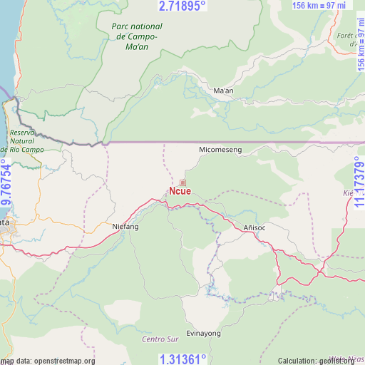
Ncue GPS coordinates[2]
2° 0' 59.148" North, 10° 28' 14.376" East
| Map corner | latitude | longitude |
|---|---|---|
| Upper-left | 2.71895°, | 9.76754° |
| Center: | 2.01643°, | 10.47066° |
| Lower-right: | 1.31361°, | 11.17379° |
| Map W x H: | 156.3×156.3 km | = 97.1×97.1mi |
| max Lat: | 3.75578° ⇑41.7% North |
| Ncue: | 2.01643° |
| min Lat: | ⇓58.3% South -1.4068° |
| min Long | Ncue | max Long |
| 5.63178° | 10.47066° | 11.33528° |
| W 58.3%⇐ | ⇒41.7% E |
Elevation
Elevation of Ncue is 399 m = 1309 ft, and this is 27 m = 89 ft above average elevation for this country.
| Max E: |
1278 m = 4193 ft | 50% |
| Ncue | 399 m 1309 ft | |
| Avg. | 372 m = 1220 ft | |
Min E: |
4 m = 13 ft | 50% |
See also: Equatorial Guinea elevation on elevation.city.
Geographical zone
Ncue is located in North Torrid zone (between Equator and Tropic of Cancer). Distance of Equator is 224.2 km =139.3 mi to South.| Distance of | km | miles | from Ncue |
|---|---|---|---|
| North Pole | 9782.9 | 6078.8 | to North |
| Arctic Circle | 7177 | 4459.6 | to North |
| Tropic Cancer | 2381.7 | 1479.9 | to North |
| Equator | 224.2 | 139.3 | to South |


Nearby cities:
15 places around Ncue: (largest is in red/bold)
• Aconibe
95.3 km =59.2 mi,  147°
147°
• Acurenam
111.2 km =69.1 mi,  169°
169°
• Ayene
30.2 km =18.8 mi,  126°
126°
• Añisoc
37.1 km =23.1 mi,  116°
116°
• Bata
80.1 km =49.8 mi,  257°
257°
• Bicurga
48.4 km =30.1 mi,  180°
180°
• Bitica
114.8 km =71.3 mi,  235°
235°
• Ebebiyin
97.2 km =60.4 mi,  81°
81°
• Evinayong
65.1 km =40.5 mi, 172°
• Machinda
59.6 km =37 mi, 255°
• Mbini
106.6 km =66.2 mi, 243°
• Mikomeseng
20.7 km =12.9 mi,  49°
49°
• Mongomo
103.2 km =64.1 mi,  114°
114°
• Nsang
52.8 km =32.8 mi,  88°
88°
• Río Campo
80.4 km =50 mi,  296°
296°
Sources, notices
• [Note1] Compared only with cities in Equatorial Guinea existing in our database
• [Src1] Map data: © OpenStreetMap contributors (CC-BY-SA)
• [Src2] Other city data from geonames.org with taken over terms of usage.
• [Src3] Geographical zone / Annual Mean Temperature by Robert A. Rohde @ Wikipedia
