Mikomeseng geodata
Mikomeseng (Kié-Ntem) is a populated place; located in Equatorial Guinea in Africa/Malabo (GMT+1) time zone. With population of 5,813 people, there are 8 cities with bigger population in this country. Compared to other cities in Equatorial Guinea, 66.7% of cities are located further ↓South; 66.7% of cities are located further ←West and 62.5% of cities have lower elevation than Mikomeseng. Note1


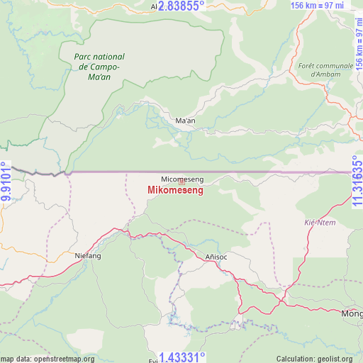
Mikomeseng GPS coordinates[2]
2° 8' 9.924" North, 10° 36' 47.592" East
| Map corner | latitude | longitude |
|---|---|---|
| Upper-left | 2.83855°, | 9.9101° |
| Center: | 2.13609°, | 10.61322° |
| Lower-right: | 1.43331°, | 11.31635° |
| Map W x H: | 156.2×156.3 km | = 97.1×97.1mi |
| max Lat: | 3.75578° ⇑33.3% North |
| Mikomeseng: | 2.13609° |
| min Lat: | ⇓66.7% South -1.4068° |
| min Long | Mikomeseng | max Long |
| 5.63178° | 10.61322° | 11.33528° |
| W 66.7%⇐ | ⇒33.3% E |
Elevation
Elevation of Mikomeseng is 542 m = 1778 ft, and this is 170 m = 558 ft above average elevation for this country.
| Max E: |
1278 m = 4193 ft | 37.5% |
| Mikomeseng | 542 m 1778 ft | |
| Avg. | 372 m = 1220 ft | |
Min E: |
4 m = 13 ft | 62.5% |
See also: Equatorial Guinea elevation on elevation.city.
Geographical zone
Mikomeseng is located in North Torrid zone (between Equator and Tropic of Cancer). Distance of Equator is 237.5 km =147.6 mi to South.| Distance of | km | miles | from Mikomeseng |
|---|---|---|---|
| North Pole | 9769.6 | 6070.5 | to North |
| Arctic Circle | 7163.7 | 4451.3 | to North |
| Tropic Cancer | 2368.4 | 1471.7 | to North |
| Equator | 237.5 | 147.6 | to South |


Nearby cities:
15 places around Mikomeseng: (largest is in red/bold)
• Aconibe
100 km =62.1 mi,  158°
158°
• Acurenam
122.8 km =76.3 mi,  178°
178°
• Ayene
32.3 km =20.1 mi, 164°
• Añisoc
34.7 km =21.6 mi,  150°
150°
• Bata
98.9 km =61.5 mi,  252°
252°
• Bicurga
63.8 km =39.6 mi,  194°
194°
• Ebebiyin
80.2 km =49.8 mi,  88°
88°
• Evinayong
78.1 km =48.5 mi, 185°
• Machinda
78.8 km =49 mi, 249°
• Mbini
126.9 km =78.9 mi,  240°
240°
• Mongomo
96.2 km =59.8 mi,  126°
126°
• Ncue
20.7 km =12.9 mi,  229°
229°
• Nsang
39 km =24.2 mi,  108°
108°
• Nsok
133.3 km =82.8 mi, 147°
• Río Campo
90.7 km =56.4 mi,  284°
284°
Sources, notices
• [Note1] Compared only with cities in Equatorial Guinea existing in our database
• [Src1] Map data: © OpenStreetMap contributors (CC-BY-SA)
• [Src2] Other city data from geonames.org with taken over terms of usage.
• [Src3] Geographical zone / Annual Mean Temperature by Robert A. Rohde @ Wikipedia
