Bata geodata
Bata (Litoral) is a seat of a first-order administrative division; located in Equatorial Guinea in Africa/Malabo (GMT+1) time zone. With population of 173,046 people, there are 0 cities with bigger population in this country. Compared to other cities in Equatorial Guinea, 54.2% of cities are located further ↑North; 58.3% of cities are located further →East and 95.8% of cities have higher elevation than Bata. Note1


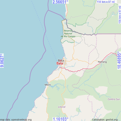
Bata GPS coordinates[2]
1° 51' 50.076" North, 9° 45' 56.952" East
| Map corner | latitude | longitude |
|---|---|---|
| Upper-left | 2.56651°, | 9.0627° |
| Center: | 1.86391°, | 9.76582° |
| Lower-right: | 1.16103°, | 10.46895° |
| Map W x H: | 156.3×156.3 km | = 97.1×97.1mi |
| max Lat: | 3.75578° ⇑54.2% North |
| Bata: | 1.86391° |
| min Lat: | ⇓45.8% South -1.4068° |
| min Long | Bata | max Long |
| 5.63178° | 9.76582° | 11.33528° |
| W 41.7%⇐ | ⇒58.3% E |
Elevation
Elevation of Bata is 13 m = 43 ft, and this is 359 m = 1178 ft below average elevation for this country.
| Max E: |
1278 m = 4193 ft | 95.8% |
| Avg. | 372 m = 1220 ft | |
| Bata | 13 m = 43 ft | |
Min E: |
4 m = 13 ft | 4.2% |
See also: Bata elevation on elevation.city.
Geographical zone
Bata is located in North Torrid zone (between Equator and Tropic of Cancer). Distance of Equator is 207.2 km =128.7 mi to South.| Distance of | km | miles | from Bata |
|---|---|---|---|
| North Pole | 9799.8 | 6089.3 | to North |
| Arctic Circle | 7193.9 | 4470.1 | to North |
| Tropic Cancer | 2398.7 | 1490.5 | to North |
| Equator | 207.2 | 128.7 | to South |


Nearby cities:
15 places around Bata: (largest is in red/bold)
• Aconibe
144.6 km =89.9 mi,  115°
115°
• Acurenam
134.8 km =83.8 mi,  133°
133°
• Ayene
102.7 km =63.8 mi,  90°
90°
• Añisoc
111.5 km =69.3 mi, 89°
• Bicurga
84 km =52.2 mi,  111°
111°
• Bitica
51.2 km =31.8 mi,  198°
198°
• Cogo
87.1 km =54.1 mi,  185°
185°
• Evinayong
99.4 km =61.8 mi, 118°
• Machinda
20.7 km =12.9 mi,  84°
84°
• Mbini
35.5 km =22.1 mi,  208°
208°
• Mikomeseng
98.9 km =61.5 mi,  72°
72°
• Mongomo
174 km =108.1 mi,  98°
98°
• Ncue
80.1 km =49.8 mi, 77°
• Nsang
132.4 km =82.3 mi, 82°
• Río Campo
53.1 km =33 mi,  6°
6°
Sources, notices
• [Note1] Compared only with cities in Equatorial Guinea existing in our database
• [Src1] Map data: © OpenStreetMap contributors (CC-BY-SA)
• [Src2] Other city data from geonames.org with taken over terms of usage.
• [Src3] Geographical zone / Annual Mean Temperature by Robert A. Rohde @ Wikipedia
