Ayene geodata
Ayene (Wele-Nzas) is a populated place; located in Equatorial Guinea in Africa/Malabo (GMT+1) time zone. With population of 3,482 people, there are 14 cities with bigger population in this country. Compared to other cities in Equatorial Guinea, 58.3% of cities are located further ↑North; 75% of cities are located further ←West and 54.2% of cities have lower elevation than Ayene. Note1


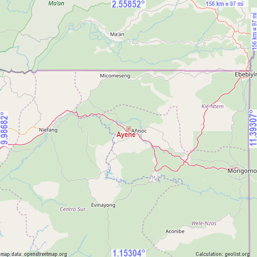
Ayene GPS coordinates[2]
1° 51' 21.312" North, 10° 41' 23.784" East
| Map corner | latitude | longitude |
|---|---|---|
| Upper-left | 2.55852°, | 9.98682° |
| Center: | 1.85592°, | 10.68994° |
| Lower-right: | 1.15304°, | 11.39307° |
| Map W x H: | 156.3×156.3 km | = 97.1×97.1mi |
| max Lat: | 3.75578° ⇑58.3% North |
| Ayene: | 1.85592° |
| min Lat: | ⇓41.7% South -1.4068° |
| min Long | Ayene | max Long |
| 5.63178° | 10.68994° | 11.33528° |
| W 75%⇐ | ⇒25% E |
Elevation
Elevation of Ayene is 443 m = 1453 ft, and this is 71 m = 233 ft above average elevation for this country.
| Max E: |
1278 m = 4193 ft | 45.8% |
| Ayene | 443 m 1453 ft | |
| Avg. | 372 m = 1220 ft | |
Min E: |
4 m = 13 ft | 54.2% |
See also: Equatorial Guinea elevation on elevation.city.
Geographical zone
Ayene is located in North Torrid zone (between Equator and Tropic of Cancer). Distance of Equator is 206.4 km =128.3 mi to South.| Distance of | km | miles | from Ayene |
|---|---|---|---|
| North Pole | 9800.7 | 6089.9 | to North |
| Arctic Circle | 7194.8 | 4470.6 | to North |
| Tropic Cancer | 2399.6 | 1491 | to North |
| Equator | 206.4 | 128.3 | to South |


Nearby cities:
15 places around Ayene: (largest is in red/bold)
• Aconibe
68 km =42.3 mi,  156°
156°
• Acurenam
91.7 km =57 mi,  182°
182°
• Añisoc
8.8 km =5.5 mi,  82°
82°
• Bata
102.7 km =63.8 mi,  270°
270°
• Bicurga
39.3 km =24.4 mi,  219°
219°
• Ebebiyin
78.9 km =49 mi,  65°
65°
• Evinayong
49.1 km =30.5 mi,  198°
198°
• Machinda
82.1 km =51 mi, 272°
• Mbini
123.3 km =76.6 mi,  255°
255°
• Mikomeseng
32.3 km =20.1 mi,  344°
344°
• Mongomo
73.8 km =45.9 mi,  110°
110°
• Ncue
30.2 km =18.8 mi,  306°
306°
• Nsang
34.1 km =21.2 mi,  56°
56°
• Nsok
103 km =64 mi,  141°
141°
• Río Campo
110.3 km =68.5 mi,  299°
299°
Sources, notices
• [Note1] Compared only with cities in Equatorial Guinea existing in our database
• [Src1] Map data: © OpenStreetMap contributors (CC-BY-SA)
• [Src2] Other city data from geonames.org with taken over terms of usage.
• [Src3] Geographical zone / Annual Mean Temperature by Robert A. Rohde @ Wikipedia
