Karpenísi geodata
Karpenísi (Central Greece) is a seat of a second-order administrative division; located in Greece in Europe/Athens (GMT+3) time zone. With population of 6,888 people, there are 185 cities with bigger population in this country. Compared to other cities in Greece, 55.4% of cities are located further ↑North; 76.5% of cities are located further →East and 99.2% of cities have lower elevation than Karpenísi. Note1
Administrative division(s):
- Level 1: Central Greece
- Level 2: Nomós Evrytanías
- Level 3: Dimos Karpenisi


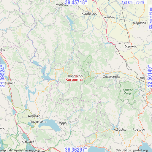
Karpenísi GPS coordinates[2]
38° 54' 43.848" North, 21° 47' 54.096" East
| Map corner | latitude | longitude |
|---|---|---|
| Upper-left | 39.45718°, | 21.09524° |
| Center: | 38.91218°, | 21.79836° |
| Lower-right: | 38.36297°, | 22.50149° |
| Map W x H: | 121.7×121.7 km | = 75.6×75.6mi |
| max Lat: | 41.72048° ⇑55.4% North |
| Karpenísi: | 38.91218° |
| min Lat: | ⇓44.6% South 34.8346° |
| min Long | Karpenísi | max Long |
| 19.40494° | 21.79836° | 29.59361° |
| W 23.5%⇐ | ⇒76.5% E |
Elevation
Elevation of Karpenísi is 948 m = 3110 ft, and this is 779.1 m = 2556 ft above average elevation for this country.
| Max E: |
1439 m = 4721 ft | 0.8% |
| Karpenísi | 948 m 3110 ft | |
| Avg. | 168.9 m = 554 ft | |
Min E: |
0 m = 0 ft | 99.2% |
See also: Greece elevation on elevation.city.
Geographical zone
Karpenísi is located in North temperate zone (between Tropic of Cancer and the Arctic Circle). Distance of this Northern Tropic circle is 1720.7 km =1069.2 mi to South.| Distance of | km | miles | from Karpenísi |
|---|---|---|---|
| North Pole | 5680.4 | 3529.6 | to North |
| Arctic Circle | 3074.5 | 1910.4 | to North |
| Tropic Cancer | 1720.7 | 1069.2 | to South |
| Equator | 4326.6 | 2688.4 | to South |


Nearby cities:
15 places around Karpenísi: (largest is in red/bold)
• Anávra
40 km =24.9 mi,  39°
39°
• Epinianá
30.2 km =18.8 mi,  328°
328°
• Fourná
17.7 km =11 mi,  22°
22°
• Ftéri
21.5 km =13.4 mi,  93°
93°
• Kerasochóri
17.3 km =10.7 mi,  306°
306°
• Makrakómi
27.6 km =17.1 mi,  83°
83°
• Neochóri
40.6 km =25.2 mi,  351°
351°
• Palioúri
37.7 km =23.4 mi, 24°
• Pandánassa
40.4 km =25.1 mi,  211°
211°
• Perdikáki
40.6 km =25.2 mi,  292°
292°
• Raptópoulo
38 km =23.6 mi, 313°
• Rentína
22.9 km =14.2 mi, 42°
• Spercheiáda
28.5 km =17.7 mi, 91°
• Thérmo
39.4 km =24.5 mi,  196°
196°
• Ágrafa
28.1 km =17.5 mi, 332°
Sources, notices
• [Note1] Compared only with cities in Greece existing in our database
• [Src1] Map data: © OpenStreetMap contributors (CC-BY-SA)
• [Src2] Other city data from geonames.org with taken over terms of usage.
• [Src3] Geographical zone / Annual Mean Temperature by Robert A. Rohde @ Wikipedia
