Escuintla geodata
Escuintla is a seat of a first-order administrative division; located in Guatemala in America/Guatemala (GMT-6) time zone. With population of 103,165 people, there are 7 cities with bigger population in this country. Compared to other cities in Guatemala, 90.9% of cities are located further ↑North; 56.6% of cities are located further ←West and 80.5% of cities have higher elevation than Escuintla. Note1


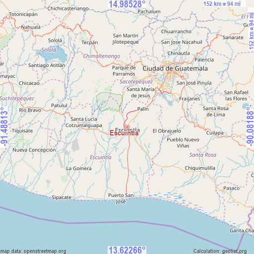
Escuintla GPS coordinates[2]
14° 18' 18" North, 90° 47' 6" West
| Map corner | latitude | longitude |
|---|---|---|
| Upper-left | 14.98528°, | -91.48813° |
| Center: | 14.305°, | -90.785° |
| Lower-right: | 13.62266°, | -90.08188° |
| Map W x H: | 151.5×151.5 km | = 94.1×94.1mi |
| max Lat: | 17.06606° ⇑90.9% North |
| Escuintla: | 14.305° |
| min Lat: | ⇓9.1% South 13.9274° |
| min Long | Escuintla | max Long |
| -92.19298° | -90.785° | -88.59444° |
| W 56.6%⇐ | ⇒43.4% E |
Elevation
Elevation of Escuintla is 356 m = 1168 ft, and this is 911 m = 2989 ft below average elevation for this country.
| Max E: |
3254 m = 10676 ft | 80.5% |
| Avg. | 1267 m = 4157 ft | |
| Escuintla | 356 m = 1168 ft | |
Min E: |
1 m = 3 ft | 19.5% |
See also: Escuintla elevation on elevation.city.
Geographical zone
Escuintla is located in North Torrid zone (between Equator and Tropic of Cancer). Distance of this Northern Tropic circle is 1015.4 km =630.9 mi to North.| Distance of | km | miles | from Escuintla |
|---|---|---|---|
| North Pole | 8416.5 | 5229.8 | to North |
| Arctic Circle | 5810.6 | 3610.5 | to North |
| Tropic Cancer | 1015.4 | 630.9 | to North |
| Equator | 1590.6 | 988.4 | to South |


Nearby cities:
15 places around Escuintla: (largest is in red/bold)
• Alotenango
19.6 km =12.2 mi,  352°
352°
• Amatitlán
25.1 km =15.6 mi,  40°
40°
• Ciudad Vieja
24.5 km =15.2 mi,  5°
5°
• Guanagazapa
17.7 km =11 mi,  120°
120°
• La Democracia
19.3 km =12 mi,  244°
244°
• Masagua
13.2 km =8.2 mi,  210°
210°
• Palín
14.5 km =9 mi, 40°
• San Antonio Aguas Calientes
26.9 km =16.7 mi,  1°
1°
• San Miguel Dueñas
24.2 km =15 mi,  356°
356°
• San Vicente Pacaya
20.1 km =12.5 mi,  52°
52°
• Santa Catarina Barahona
27.4 km =17 mi, 359°
• Santa Lucía Cotzumalguapa
25.9 km =16.1 mi,  277°
277°
• Santa María de Jesús
22.6 km =14 mi,  20°
20°
• Siquinalá
19.4 km =12.1 mi,  270°
270°
• Yepocapa
28.5 km =17.7 mi,  320°
320°
Sources, notices
• [Note1] Compared only with cities in Guatemala existing in our database
• [Src1] Map data: © OpenStreetMap contributors (CC-BY-SA)
• [Src2] Other city data from geonames.org with taken over terms of usage.
• [Src3] Geographical zone / Annual Mean Temperature by Robert A. Rohde @ Wikipedia
