Masagua geodata
Masagua (Escuintla) is a seat of a second-order administrative division; located in Guatemala in America/Guatemala (GMT-6) time zone. With population of 10,045 people, there are 127 cities with bigger population in this country. Compared to other cities in Guatemala, 94.4% of cities are located further ↑North; 53.1% of cities are located further ←West and 94.7% of cities have higher elevation than Masagua. Note1


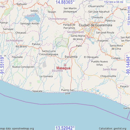
Masagua GPS coordinates[2]
14° 12' 11.016" North, 90° 50' 53.016" West
| Map corner | latitude | longitude |
|---|---|---|
| Upper-left | 14.88365°, | -91.55119° |
| Center: | 14.20306°, | -90.84806° |
| Lower-right: | 13.52042°, | -90.14494° |
| Map W x H: | 151.6×151.6 km | = 94.2×94.2mi |
| max Lat: | 17.06606° ⇑94.4% North |
| Masagua: | 14.20306° |
| min Lat: | ⇓5.6% South 13.9274° |
| min Long | Masagua | max Long |
| -92.19298° | -90.84806° | -88.59444° |
| W 53.1%⇐ | ⇒46.9% E |
Elevation
Elevation of Masagua is 118 m = 387 ft, and this is 1149 m = 3770 ft below average elevation for this country.
| Max E: |
3254 m = 10676 ft | 94.7% |
| Avg. | 1267 m = 4157 ft | |
| Masagua | 118 m = 387 ft | |
Min E: |
1 m = 3 ft | 5.3% |
See also: Guatemala elevation on elevation.city.
Geographical zone
Masagua is located in North Torrid zone (between Equator and Tropic of Cancer). Distance of this Northern Tropic circle is 1026.7 km =638 mi to North.| Distance of | km | miles | from Masagua |
|---|---|---|---|
| North Pole | 8427.8 | 5236.8 | to North |
| Arctic Circle | 5821.9 | 3617.6 | to North |
| Tropic Cancer | 1026.7 | 638 | to North |
| Equator | 1579.2 | 981.3 | to South |


Nearby cities:
15 places around Masagua: (largest is in red/bold)
• Alotenango
31.1 km =19.3 mi,  8°
8°
• Ciudad Vieja
36.8 km =22.9 mi, 14°
• Escuintla
13.2 km =8.2 mi,  30°
30°
• Guanagazapa
22.2 km =13.8 mi,  83°
83°
• Iztapa
33.6 km =20.9 mi,  153°
153°
• La Democracia
11.1 km =6.9 mi,  286°
286°
• La Gomera
25.9 km =16.1 mi,  238°
238°
• Palín
27.6 km =17.1 mi,  36°
36°
• Puerto San José
30.8 km =19.1 mi,  174°
174°
• San Miguel Dueñas
35.9 km =22.3 mi, 8°
• San Vicente Pacaya
32.8 km =20.4 mi, 44°
• Santa Lucía Cotzumalguapa
23.9 km =14.9 mi,  307°
307°
• Santa María de Jesús
35.6 km =22.1 mi,  24°
24°
• Siquinalá
17 km =10.6 mi, 312°
• Yepocapa
35.1 km =21.8 mi,  341°
341°
Sources, notices
• [Note1] Compared only with cities in Guatemala existing in our database
• [Src1] Map data: © OpenStreetMap contributors (CC-BY-SA)
• [Src2] Other city data from geonames.org with taken over terms of usage.
• [Src3] Geographical zone / Annual Mean Temperature by Robert A. Rohde @ Wikipedia
