Rabinal geodata
Rabinal (Baja Verapaz) is a seat of a second-order administrative division; located in Guatemala in America/Guatemala (GMT-6) time zone. With population of 10,737 people, there are 118 cities with bigger population in this country. Compared to other cities in Guatemala, 71.7% of cities are located further ↓South; 67% of cities are located further ←West and 59.3% of cities have higher elevation than Rabinal. Note1


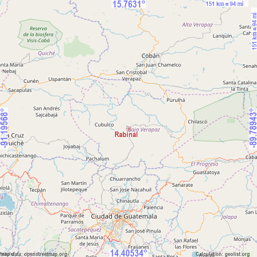
Rabinal GPS coordinates[2]
15° 5' 7.08" North, 90° 29' 33.18" West
| Map corner | latitude | longitude |
|---|---|---|
| Upper-left | 15.7631°, | -91.19568° |
| Center: | 15.0853°, | -90.49255° |
| Lower-right: | 14.40534°, | -89.78943° |
| Map W x H: | 151×151 km | = 93.8×93.8mi |
| max Lat: | 17.06606° ⇑28.3% North |
| Rabinal: | 15.0853° |
| min Lat: | ⇓71.7% South 13.9274° |
| min Long | Rabinal | max Long |
| -92.19298° | -90.49255° | -88.59444° |
| W 67%⇐ | ⇒33% E |
Elevation
Elevation of Rabinal is 969 m = 3179 ft, and this is 298 m = 978 ft below average elevation for this country.
| Max E: |
3254 m = 10676 ft | 59.3% |
| Avg. | 1267 m = 4157 ft | |
| Rabinal | 969 m = 3179 ft | |
Min E: |
1 m = 3 ft | 40.7% |
See also: Guatemala elevation on elevation.city.
Geographical zone
Rabinal is located in North Torrid zone (between Equator and Tropic of Cancer). Distance of this Northern Tropic circle is 928.6 km =577 mi to North.| Distance of | km | miles | from Rabinal |
|---|---|---|---|
| North Pole | 8329.7 | 5175.8 | to North |
| Arctic Circle | 5723.8 | 3556.6 | to North |
| Tropic Cancer | 928.6 | 577 | to North |
| Equator | 1677.3 | 1042.2 | to South |


Nearby cities:
15 places around Rabinal: (largest is in red/bold)
• Chuarrancho
29.8 km =18.5 mi,  184°
184°
• Cubulco
14.8 km =9.2 mi,  278°
278°
• El Chol
13.9 km =8.6 mi, 177°
• Granados
19.1 km =11.9 mi,  189°
189°
• Joyabaj
34.7 km =21.6 mi,  252°
252°
• Pachalum
25.6 km =15.9 mi,  225°
225°
• Purulhá
37.3 km =23.2 mi,  57°
57°
• Salamá
18.8 km =11.7 mi,  84°
84°
• San Cristóbal Verapaz
35.4 km =22 mi,  347°
347°
• San Jerónimo
27.2 km =16.9 mi,  95°
95°
• San Miguel Chicaj
10.6 km =6.6 mi, 84°
• San Pedro Ayampuc
34.3 km =21.3 mi,  172°
172°
• Santa Cruz Verapaz
31.9 km =19.8 mi,  11°
11°
• Tactic
30.2 km =18.8 mi,  29°
29°
• Tamahú
37.1 km =23.1 mi,  47°
47°
Sources, notices
• [Note1] Compared only with cities in Guatemala existing in our database
• [Src1] Map data: © OpenStreetMap contributors (CC-BY-SA)
• [Src2] Other city data from geonames.org with taken over terms of usage.
• [Src3] Geographical zone / Annual Mean Temperature by Robert A. Rohde @ Wikipedia
