San Pedro Carchá geodata
San Pedro Carchá (Alta Verapaz) is a seat of a second-order administrative division; located in Guatemala in America/Guatemala (GMT-6) time zone. With population of 13,332 people, there are 93 cities with bigger population in this country. Compared to other cities in Guatemala, 87% of cities are located further ↓South; 74.3% of cities are located further ←West and 51% of cities have lower elevation than San Pedro Carchá. Note1


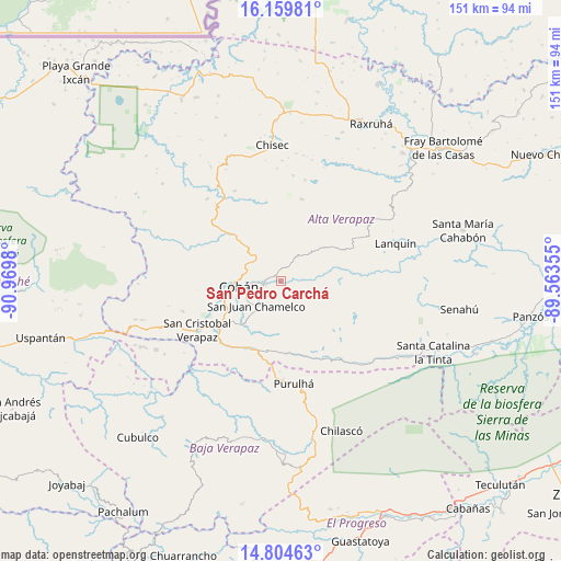
San Pedro Carchá GPS coordinates[2]
15° 28' 59.988" North, 90° 16' 0.012" West
| Map corner | latitude | longitude |
|---|---|---|
| Upper-left | 16.15981°, | -90.9698° |
| Center: | 15.48333°, | -90.26667° |
| Lower-right: | 14.80463°, | -89.56355° |
| Map W x H: | 150.7×150.7 km | = 93.6×93.6mi |
| max Lat: | 17.06606° ⇑13% North |
| San Pedro Carchá: | 15.48333° |
| min Lat: | ⇓87% South 13.9274° |
| min Long | San Pedro Carch | max Long |
| -92.19298° | -90.26667° | -88.59444° |
| W 74.3%⇐ | ⇒25.7% E |
Elevation
Elevation of San Pedro Carchá is 1278 m = 4193 ft, and this is 11 m = 36 ft above average elevation for this country.
| Max E: |
3254 m = 10676 ft | 49% |
| San Pedro Carchá | 1278 m 4193 ft | |
| Avg. | 1267 m = 4157 ft | |
Min E: |
1 m = 3 ft | 51% |
See also: Guatemala elevation on elevation.city.
Geographical zone
San Pedro Carchá is located in North Torrid zone (between Equator and Tropic of Cancer). Distance of this Northern Tropic circle is 884.3 km =549.5 mi to North.| Distance of | km | miles | from San Pedro Carchá |
|---|---|---|---|
| North Pole | 8285.5 | 5148.4 | to North |
| Arctic Circle | 5679.6 | 3529.1 | to North |
| Tropic Cancer | 884.3 | 549.5 | to North |
| Equator | 1721.6 | 1069.8 | to South |


Nearby cities:
15 places around San Pedro Carchá: (largest is in red/bold)
• Chisec
37.1 km =23.1 mi,  357°
357°
• Cobán
11.2 km =7 mi,  262°
262°
• La Tinta
45.1 km =28 mi,  114°
114°
• Lanquín
33.4 km =20.8 mi,  73°
73°
• Purulhá
25.1 km =15.6 mi,  163°
163°
• Salamá
42.7 km =26.5 mi,  187°
187°
• San Cristóbal Verapaz
33.4 km =20.8 mi,  253°
253°
• San Jerónimo
47.1 km =29.3 mi,  176°
176°
• San Juan Chamelco
9.1 km =5.7 mi,  232°
232°
• San Miguel Chicaj
45.3 km =28.1 mi,  197°
197°
• Santa Cruz Verapaz
22.1 km =13.7 mi, 234°
• Senahú
47.4 km =29.5 mi,  101°
101°
• Tactic
20.2 km =12.6 mi,  207°
207°
• Tamahú
19.7 km =12.2 mi,  170°
170°
• Tucurú
29.6 km =18.4 mi,  133°
133°
Sources, notices
• [Note1] Compared only with cities in Guatemala existing in our database
• [Src1] Map data: © OpenStreetMap contributors (CC-BY-SA)
• [Src2] Other city data from geonames.org with taken over terms of usage.
• [Src3] Geographical zone / Annual Mean Temperature by Robert A. Rohde @ Wikipedia
