Tucurú geodata
Tucurú (Alta Verapaz) is a seat of a second-order administrative division; located in Guatemala in America/Guatemala (GMT-6) time zone. With population of 4,772 people, there are 208 cities with bigger population in this country. Compared to other cities in Guatemala, 78.8% of cities are located further ↓South; 79.6% of cities are located further ←West and 71.7% of cities have higher elevation than Tucurú. Note1


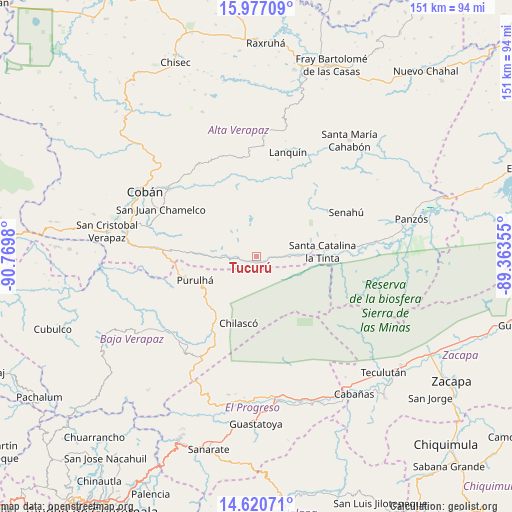
Tucurú GPS coordinates[2]
15° 18' 0" North, 90° 4' 0.012" West
| Map corner | latitude | longitude |
|---|---|---|
| Upper-left | 15.97709°, | -90.7698° |
| Center: | 15.3°, | -90.06667° |
| Lower-right: | 14.62071°, | -89.36355° |
| Map W x H: | 150.8×150.8 km | = 93.7×93.7mi |
| max Lat: | 17.06606° ⇑21.2% North |
| Tucurú: | 15.3° |
| min Lat: | ⇓78.8% South 13.9274° |
| min Long | Tucurú | max Long |
| -92.19298° | -90.06667° | -88.59444° |
| W 79.6%⇐ | ⇒20.4% E |
Elevation
Elevation of Tucurú is 570 m = 1870 ft, and this is 697 m = 2287 ft below average elevation for this country.
| Max E: |
3254 m = 10676 ft | 71.7% |
| Avg. | 1267 m = 4157 ft | |
| Tucurú | 570 m = 1870 ft | |
Min E: |
1 m = 3 ft | 28.3% |
See also: Guatemala elevation on elevation.city.
Geographical zone
Tucurú is located in North Torrid zone (between Equator and Tropic of Cancer). Distance of this Northern Tropic circle is 904.7 km =562.2 mi to North.| Distance of | km | miles | from Tucurú |
|---|---|---|---|
| North Pole | 8305.9 | 5161 | to North |
| Arctic Circle | 5700 | 3541.8 | to North |
| Tropic Cancer | 904.7 | 562.2 | to North |
| Equator | 1701.2 | 1057.1 | to South |


Nearby cities:
15 places around Tucurú: (largest is in red/bold)
• Cahabón
40 km =24.9 mi,  42°
42°
• Cobán
37.7 km =23.4 mi,  300°
300°
• La Tinta
19.7 km =12.2 mi,  84°
84°
• Lanquín
31.5 km =19.6 mi,  19°
19°
• Morazán
41.6 km =25.8 mi,  191°
191°
• Purulhá
14.8 km =9.2 mi,  255°
255°
• Salamá
34.8 km =21.6 mi,  230°
230°
• San Agustín Acasaguastlán
40.4 km =25.1 mi,  164°
164°
• San Jerónimo
32.5 km =20.2 mi,  214°
214°
• San Juan Chamelco
32.2 km =20 mi, 297°
• San Pedro Carchá
29.6 km =18.4 mi,  313°
313°
• Santa Cruz Verapaz
40 km =24.9 mi,  280°
280°
• Senahú
27.4 km =17 mi,  66°
66°
• Tactic
31 km =19.3 mi,  274°
274°
• Tamahú
18.2 km =11.3 mi, 273°
Sources, notices
• [Note1] Compared only with cities in Guatemala existing in our database
• [Src1] Map data: © OpenStreetMap contributors (CC-BY-SA)
• [Src2] Other city data from geonames.org with taken over terms of usage.
• [Src3] Geographical zone / Annual Mean Temperature by Robert A. Rohde @ Wikipedia
