Tamahú geodata
Tamahú (Alta Verapaz) is a populated place; located in Guatemala in America/Guatemala (GMT-6) time zone. With population of 1,012 people, there are 313 cities with bigger population in this country. Compared to other cities in Guatemala, 79.4% of cities are located further ↓South; 75.5% of cities are located further ←West and 54.9% of cities have higher elevation than Tamahú. Note1


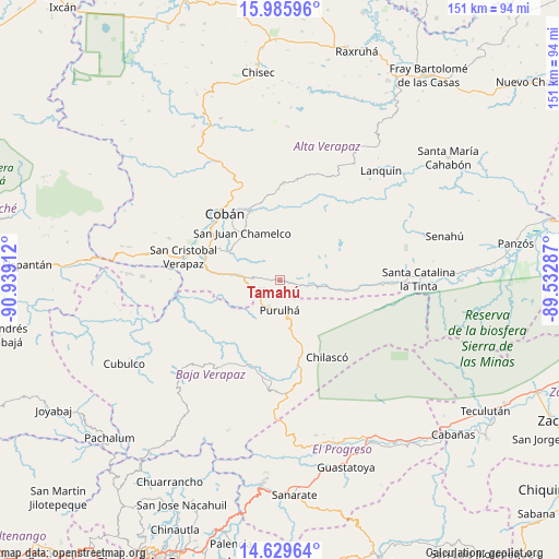
Tamahú GPS coordinates[2]
15° 18' 32.04" North, 90° 14' 9.564" West
| Map corner | latitude | longitude |
|---|---|---|
| Upper-left | 15.98596°, | -90.93912° |
| Center: | 15.3089°, | -90.23599° |
| Lower-right: | 14.62964°, | -89.53287° |
| Map W x H: | 150.8×150.8 km | = 93.7×93.7mi |
| max Lat: | 17.06606° ⇑20.6% North |
| Tamahú: | 15.3089° |
| min Lat: | ⇓79.4% South 13.9274° |
| min Long | Tamahú | max Long |
| -92.19298° | -90.23599° | -88.59444° |
| W 75.5%⇐ | ⇒24.5% E |
Elevation
Elevation of Tamahú is 1095 m = 3593 ft, and this is 172 m = 564 ft below average elevation for this country.
| Max E: |
3254 m = 10676 ft | 54.9% |
| Avg. | 1267 m = 4157 ft | |
| Tamahú | 1095 m = 3593 ft | |
Min E: |
1 m = 3 ft | 45.1% |
See also: Guatemala elevation on elevation.city.
Geographical zone
Tamahú is located in North Torrid zone (between Equator and Tropic of Cancer). Distance of this Northern Tropic circle is 903.7 km =561.5 mi to North.| Distance of | km | miles | from Tamahú |
|---|---|---|---|
| North Pole | 8304.9 | 5160.4 | to North |
| Arctic Circle | 5699 | 3541.2 | to North |
| Tropic Cancer | 903.7 | 561.5 | to North |
| Equator | 1702.2 | 1057.7 | to South |


Nearby cities:
15 places around Tamahú: (largest is in red/bold)
• Cobán
23.1 km =14.4 mi,  321°
321°
• La Tinta
37.8 km =23.5 mi,  88°
88°
• Lanquín
40.7 km =25.3 mi,  45°
45°
• Morazán
43 km =26.7 mi,  166°
166°
• Purulhá
6.1 km =3.8 mi,  140°
140°
• Rabinal
37.1 km =23.1 mi,  227°
227°
• Salamá
24.6 km =15.3 mi,  201°
201°
• San Cristóbal Verapaz
36.6 km =22.7 mi,  285°
285°
• San Jerónimo
27.6 km =17.1 mi,  181°
181°
• San Juan Chamelco
17.3 km =10.7 mi, 322°
• San Miguel Chicaj
29.3 km =18.2 mi,  215°
215°
• San Pedro Carchá
19.7 km =12.2 mi,  350°
350°
• Santa Cruz Verapaz
22.1 km =13.7 mi, 286°
• Tactic
12.8 km =8 mi,  276°
276°
• Tucurú
18.2 km =11.3 mi, 93°
Sources, notices
• [Note1] Compared only with cities in Guatemala existing in our database
• [Src1] Map data: © OpenStreetMap contributors (CC-BY-SA)
• [Src2] Other city data from geonames.org with taken over terms of usage.
• [Src3] Geographical zone / Annual Mean Temperature by Robert A. Rohde @ Wikipedia
