San Rafael Pie de la Cuesta geodata
San Rafael Pie de la Cuesta (San Marcos) is a seat of a second-order administrative division; located in Guatemala in America/Guatemala (GMT-6) time zone. With population of 4,320 people, there are 216 cities with bigger population in this country. Compared to other cities in Guatemala, 60.2% of cities are located further ↓South; 94.7% of cities are located further →East and 56.3% of cities have higher elevation than San Rafael Pie de la Cuesta. Note1
Current local time in San Rafael Pie de la Cuesta:
02:39 PM, SundayDifference from your time zone: hours


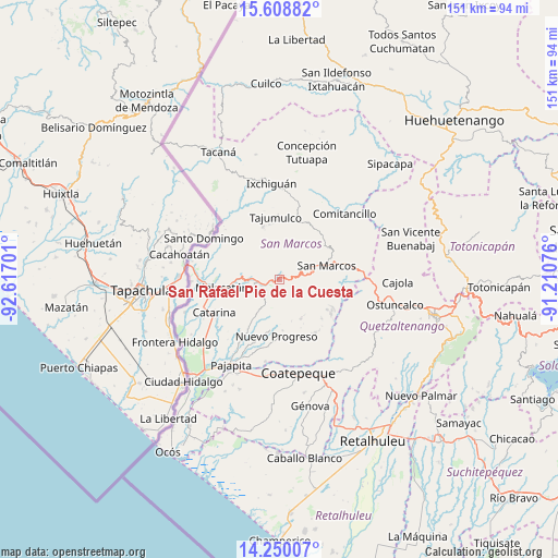
San Rafael Pie de la Cuesta GPS coordinates[2]
14° 55' 49.872" North, 91° 54' 49.968" West
| Map corner | latitude | longitude |
|---|---|---|
| Upper-left | 15.60882°, | -92.61701° |
| Center: | 14.93052°, | -91.91388° |
| Lower-right: | 14.25007°, | -91.21076° |
| Map W x H: | 151.1×151.1 km | = 93.9×93.9mi |
| max Lat: | 17.06606° ⇑39.8% North |
| San Rafael Pie de la Cuesta: | 14.93052° |
| min Lat: | ⇓60.2% South 13.9274° |
| min Long | San Rafael Pie | max Long |
| -92.19298° | -91.91388° | -88.59444° |
| W 5.3%⇐ | ⇒94.7% E |
Elevation
Elevation of San Rafael Pie de la Cuesta is 1044 m = 3425 ft, and this is 223 m = 732 ft below average elevation for this country.
| Max E: |
3254 m = 10676 ft | 56.3% |
| Avg. | 1267 m = 4157 ft | |
| San Rafael Pie de la Cuesta | 1044 m = 3425 ft | |
Min E: |
1 m = 3 ft | 43.7% |
See also: Guatemala elevation on elevation.city.
Geographical zone
San Rafael Pie de la Cuesta is located in North Torrid zone (between Equator and Tropic of Cancer). Distance of this Northern Tropic circle is 945.8 km =587.7 mi to North.| Distance of | km | miles | from San Rafael Pie de la Cuesta |
|---|---|---|---|
| North Pole | 8346.9 | 5186.5 | to North |
| Arctic Circle | 5741.1 | 3567.4 | to North |
| Tropic Cancer | 945.8 | 587.7 | to North |
| Equator | 1660.1 | 1031.5 | to South |


Nearby cities:
15 places around San Rafael Pie de la Cuesta: (largest is in red/bold)
• Catarina
19.5 km =12.1 mi,  243°
243°
• El Quetzal
20.8 km =12.9 mi,  150°
150°
• El Rodeo
6.9 km =4.3 mi,  255°
255°
• El Tumbador
7.7 km =4.8 mi,  196°
196°
• Esquipulas Palo Gordo
9.6 km =6 mi,  82°
82°
• La Reforma
17.4 km =10.8 mi, 145°
• Malacatán
15.6 km =9.7 mi, 262°
• Nuevo Progreso
15.4 km =9.6 mi,  182°
182°
• San Antonio Sacatepéquez
19.9 km =12.4 mi, 80°
• San Cristóbal Cucho
14.5 km =9 mi,  101°
101°
• San Lorenzo
22.2 km =13.8 mi,  59°
59°
• San Marcos
13.4 km =8.3 mi,  73°
73°
• San Pablo
9.7 km =6 mi,  271°
271°
• San Pedro Sacatepéquez
16.9 km =10.5 mi, 75°
• Tajumulco
17 km =10.6 mi,  356°
356°
Sources, notices
• [Note1] Compared only with cities in Guatemala existing in our database
• [Src1] Map data: © OpenStreetMap contributors (CC-BY-SA)
• [Src2] Other city data from geonames.org with taken over terms of usage.
• [Src3] Geographical zone / Annual Mean Temperature by Robert A. Rohde @ Wikipedia
