Lanquín geodata
Lanquín (Alta Verapaz) is a seat of a second-order administrative division; located in Guatemala in America/Guatemala (GMT-6) time zone. With population of 2,006 people, there are 277 cities with bigger population in this country. Compared to other cities in Guatemala, 89.1% of cities are located further ↓South; 81.7% of cities are located further ←West and 72% of cities have higher elevation than Lanquín. Note1


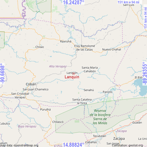
Lanquín GPS coordinates[2]
15° 34' 0.012" North, 89° 58' 0.012" West
| Map corner | latitude | longitude |
|---|---|---|
| Upper-left | 16.24287°, | -90.6698° |
| Center: | 15.56667°, | -89.96667° |
| Lower-right: | 14.88824°, | -89.26355° |
| Map W x H: | 150.6×150.6 km | = 93.6×93.6mi |
| max Lat: | 17.06606° ⇑10.9% North |
| Lanquín: | 15.56667° |
| min Lat: | ⇓89.1% South 13.9274° |
| min Long | Lanquín | max Long |
| -92.19298° | -89.96667° | -88.59444° |
| W 81.7%⇐ | ⇒18.3% E |
Elevation
Elevation of Lanquín is 556 m = 1824 ft, and this is 711 m = 2333 ft below average elevation for this country.
| Max E: |
3254 m = 10676 ft | 72% |
| Avg. | 1267 m = 4157 ft | |
| Lanquín | 556 m = 1824 ft | |
Min E: |
1 m = 3 ft | 28% |
See also: Guatemala elevation on elevation.city.
Geographical zone
Lanquín is located in North Torrid zone (between Equator and Tropic of Cancer). Distance of this Northern Tropic circle is 875.1 km =543.8 mi to North.| Distance of | km | miles | from Lanquín |
|---|---|---|---|
| North Pole | 8276.2 | 5142.6 | to North |
| Arctic Circle | 5670.3 | 3523.4 | to North |
| Tropic Cancer | 875.1 | 543.8 | to North |
| Equator | 1730.9 | 1075.5 | to South |


Nearby cities:
15 places around Lanquín: (largest is in red/bold)
• Cahabón
16.1 km =10 mi,  90°
90°
• Chahal Guatemala
46.1 km =28.6 mi,  57°
57°
• Chisec
43.8 km =27.2 mi,  309°
309°
• Cobán
44.6 km =27.7 mi,  256°
256°
• Fray Bartolomé de Las Casas
28.8 km =17.9 mi,  16°
16°
• La Tinta
29.2 km =18.1 mi,  162°
162°
• Panzós
37.1 km =23.1 mi,  119°
119°
• Purulhá
41.7 km =25.9 mi,  216°
216°
• Raxruhá
34.1 km =21.2 mi,  347°
347°
• San Juan Chamelco
42 km =26.1 mi,  249°
249°
• San Pedro Carchá
33.4 km =20.8 mi, 253°
• Senahú
23.4 km =14.5 mi,  142°
142°
• Tactic
49.7 km =30.9 mi,  236°
236°
• Tamahú
40.7 km =25.3 mi,  225°
225°
• Tucurú
31.5 km =19.6 mi,  199°
199°
Sources, notices
• [Note1] Compared only with cities in Guatemala existing in our database
• [Src1] Map data: © OpenStreetMap contributors (CC-BY-SA)
• [Src2] Other city data from geonames.org with taken over terms of usage.
• [Src3] Geographical zone / Annual Mean Temperature by Robert A. Rohde @ Wikipedia
