Olopa geodata
Olopa (Chiquimula) is a seat of a second-order administrative division; located in Guatemala in America/Guatemala (GMT-6) time zone. With population of 1,690 people, there are 287 cities with bigger population in this country. Compared to other cities in Guatemala, 61.1% of cities are located further ↑North; 97.9% of cities are located further ←West and 54.3% of cities have lower elevation than Olopa. Note1


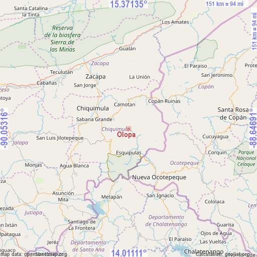
Olopa GPS coordinates[2]
14° 41' 32.244" North, 89° 21' 0.108" West
| Map corner | latitude | longitude |
|---|---|---|
| Upper-left | 15.37135°, | -90.05316° |
| Center: | 14.69229°, | -89.35003° |
| Lower-right: | 14.01111°, | -88.64691° |
| Map W x H: | 151.2×151.2 km | = 94×94mi |
| max Lat: | 17.06606° ⇑61.1% North |
| Olopa: | 14.69229° |
| min Lat: | ⇓38.9% South 13.9274° |
| min Long | Olopa | max Long |
| -92.19298° | -89.35003° | -88.59444° |
| W 97.9%⇐ | ⇒2.1% E |
Elevation
Elevation of Olopa is 1371 m = 4498 ft, and this is 104 m = 341 ft above average elevation for this country.
| Max E: |
3254 m = 10676 ft | 45.7% |
| Olopa | 1371 m 4498 ft | |
| Avg. | 1267 m = 4157 ft | |
Min E: |
1 m = 3 ft | 54.3% |
See also: Guatemala elevation on elevation.city.
Geographical zone
Olopa is located in North Torrid zone (between Equator and Tropic of Cancer). Distance of this Northern Tropic circle is 972.3 km =604.2 mi to North.| Distance of | km | miles | from Olopa |
|---|---|---|---|
| North Pole | 8373.4 | 5203 | to North |
| Arctic Circle | 5767.5 | 3583.8 | to North |
| Tropic Cancer | 972.3 | 604.2 | to North |
| Equator | 1633.6 | 1015.1 | to South |


Nearby cities:
15 places around Olopa: (largest is in red/bold)
• Agua Blanca
38.7 km =24 mi,  236°
236°
• Camotán
14.4 km =8.9 mi,  350°
350°
• Chiquimula
24.2 km =15 mi,  299°
299°
• Concepción Las Minas
22.2 km =13.8 mi,  211°
211°
• Esquipulas
14.1 km =8.8 mi,  180°
180°
• Estanzuela
41.4 km =25.7 mi,  325°
325°
• Ipala
29.9 km =18.6 mi,  253°
253°
• Jocotán
14.9 km =9.3 mi,  343°
343°
• La Unión
31.2 km =19.4 mi,  11°
11°
• Quezaltepeque
11.8 km =7.3 mi, 237°
• San Jacinto
16.4 km =10.2 mi,  259°
259°
• San Jorge
36.7 km =22.8 mi,  316°
316°
• San José La Arada
25.2 km =15.7 mi,  276°
276°
• San Juan Ermita
11.8 km =7.3 mi,  313°
313°
• Zacapa
36.7 km =22.8 mi, 328°
Sources, notices
• [Note1] Compared only with cities in Guatemala existing in our database
• [Src1] Map data: © OpenStreetMap contributors (CC-BY-SA)
• [Src2] Other city data from geonames.org with taken over terms of usage.
• [Src3] Geographical zone / Annual Mean Temperature by Robert A. Rohde @ Wikipedia
