Chuarrancho geodata
Chuarrancho (Guatemala) is a seat of a second-order administrative division; located in Guatemala in America/Guatemala (GMT-6) time zone. With population of 7,149 people, there are 171 cities with bigger population in this country. Compared to other cities in Guatemala, 51.3% of cities are located further ↓South; 65.8% of cities are located further ←West and 52.2% of cities have lower elevation than Chuarrancho. Note1


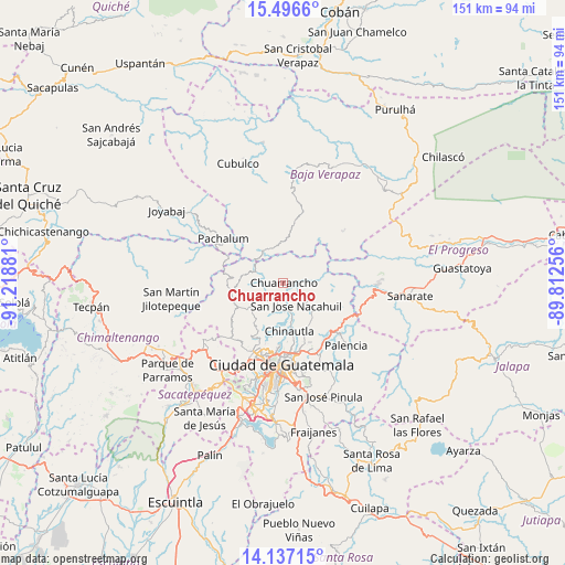
Chuarrancho GPS coordinates[2]
14° 49' 4.584" North, 90° 30' 56.448" West
| Map corner | latitude | longitude |
|---|---|---|
| Upper-left | 15.4966°, | -91.21881° |
| Center: | 14.81794°, | -90.51568° |
| Lower-right: | 14.13715°, | -89.81256° |
| Map W x H: | 151.2×151.2 km | = 94×94mi |
| max Lat: | 17.06606° ⇑48.7% North |
| Chuarrancho: | 14.81794° |
| min Lat: | ⇓51.3% South 13.9274° |
| min Long | Chuarrancho | max Long |
| -92.19298° | -90.51568° | -88.59444° |
| W 65.8%⇐ | ⇒34.2% E |
Elevation
Elevation of Chuarrancho is 1289 m = 4229 ft, and this is 22 m = 72 ft above average elevation for this country.
| Max E: |
3254 m = 10676 ft | 47.8% |
| Chuarrancho | 1289 m 4229 ft | |
| Avg. | 1267 m = 4157 ft | |
Min E: |
1 m = 3 ft | 52.2% |
See also: Guatemala elevation on elevation.city.
Geographical zone
Chuarrancho is located in North Torrid zone (between Equator and Tropic of Cancer). Distance of this Northern Tropic circle is 958.3 km =595.5 mi to North.| Distance of | km | miles | from Chuarrancho |
|---|---|---|---|
| North Pole | 8359.5 | 5194.4 | to North |
| Arctic Circle | 5753.6 | 3575.1 | to North |
| Tropic Cancer | 958.3 | 595.5 | to North |
| Equator | 1647.6 | 1023.8 | to South |


Nearby cities:
15 places around Chuarrancho: (largest is in red/bold)
• Chinautla
12.9 km =8 mi,  172°
172°
• El Chol
16.1 km =10 mi,  10°
10°
• Granados
11 km =6.8 mi,  355°
355°
• Guatemala City
19.7 km =12.2 mi,  179°
179°
• Mixco
23 km =14.3 mi,  205°
205°
• Pachalum
19.8 km =12.3 mi,  306°
306°
• Palencia
23.9 km =14.9 mi,  134°
134°
• San Antonio La Paz
25.7 km =16 mi,  104°
104°
• San José del Golfo
16.5 km =10.3 mi,  111°
111°
• San Juan Sacatepéquez
17.7 km =11 mi,  231°
231°
• San Pedro Ayampuc
8 km =5 mi,  122°
122°
• San Pedro Sacatepéquez
20 km =12.4 mi,  222°
222°
• San Raimundo
10.4 km =6.5 mi,  235°
235°
• Santiago Sacatepéquez
26.7 km =16.6 mi, 220°
• Santo Domingo Xenacoj
25 km =15.5 mi, 232°
Sources, notices
• [Note1] Compared only with cities in Guatemala existing in our database
• [Src1] Map data: © OpenStreetMap contributors (CC-BY-SA)
• [Src2] Other city data from geonames.org with taken over terms of usage.
• [Src3] Geographical zone / Annual Mean Temperature by Robert A. Rohde @ Wikipedia
