Granados geodata
Granados (Baja Verapaz) is a seat of a second-order administrative division; located in Guatemala in America/Guatemala (GMT-6) time zone. With population of 937 people, there are 316 cities with bigger population in this country. Compared to other cities in Guatemala, 58.1% of cities are located further ↓South; 65.5% of cities are located further ←West and 61.4% of cities have higher elevation than Granados. Note1


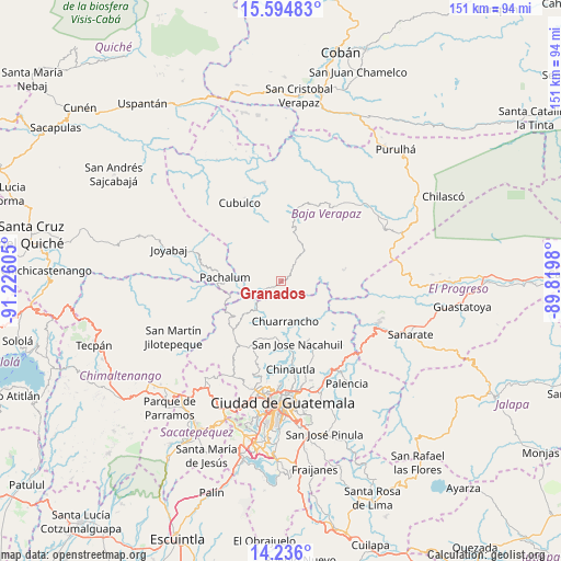
Granados GPS coordinates[2]
14° 54' 59.364" North, 90° 31' 22.512" West
| Map corner | latitude | longitude |
|---|---|---|
| Upper-left | 15.59483°, | -91.22605° |
| Center: | 14.91649°, | -90.52292° |
| Lower-right: | 14.236°, | -89.8198° |
| Map W x H: | 151.1×151.1 km | = 93.9×93.9mi |
| max Lat: | 17.06606° ⇑41.9% North |
| Granados: | 14.91649° |
| min Lat: | ⇓58.1% South 13.9274° |
| min Long | Granados | max Long |
| -92.19298° | -90.52292° | -88.59444° |
| W 65.5%⇐ | ⇒34.5% E |
Elevation
Elevation of Granados is 936 m = 3071 ft, and this is 331 m = 1086 ft below average elevation for this country.
| Max E: |
3254 m = 10676 ft | 61.4% |
| Avg. | 1267 m = 4157 ft | |
| Granados | 936 m = 3071 ft | |
Min E: |
1 m = 3 ft | 38.6% |
See also: Guatemala elevation on elevation.city.
Geographical zone
Granados is located in North Torrid zone (between Equator and Tropic of Cancer). Distance of this Northern Tropic circle is 947.4 km =588.7 mi to North.| Distance of | km | miles | from Granados |
|---|---|---|---|
| North Pole | 8348.5 | 5187.5 | to North |
| Arctic Circle | 5742.6 | 3568.3 | to North |
| Tropic Cancer | 947.4 | 588.7 | to North |
| Equator | 1658.6 | 1030.6 | to South |


Nearby cities:
15 places around Granados: (largest is in red/bold)
• Chinautla
23.9 km =14.9 mi,  174°
174°
• Chuarrancho
11 km =6.8 mi,  175°
175°
• Cubulco
23.8 km =14.8 mi,  331°
331°
• El Chol
6.2 km =3.9 mi,  37°
37°
• Guatemala City
30.7 km =19.1 mi, 178°
• Pachalum
15.1 km =9.4 mi,  273°
273°
• Rabinal
19.1 km =11.9 mi,  9°
9°
• Salamá
30.2 km =18.8 mi,  46°
46°
• San Antonio La Paz
31 km =19.3 mi,  124°
124°
• San José del Golfo
23.4 km =14.5 mi,  136°
136°
• San Juan Sacatepéquez
25.5 km =15.8 mi,  210°
210°
• San Miguel Chicaj
24.1 km =15 mi,  34°
34°
• San Pedro Ayampuc
17 km =10.6 mi,  153°
153°
• San Pedro Sacatepéquez
28.7 km =17.8 mi, 206°
• San Raimundo
18.6 km =11.6 mi,  204°
204°
Sources, notices
• [Note1] Compared only with cities in Guatemala existing in our database
• [Src1] Map data: © OpenStreetMap contributors (CC-BY-SA)
• [Src2] Other city data from geonames.org with taken over terms of usage.
• [Src3] Geographical zone / Annual Mean Temperature by Robert A. Rohde @ Wikipedia
