El Estor geodata
El Estor (Izabal) is a seat of a second-order administrative division; located in Guatemala in America/Guatemala (GMT-6) time zone. With population of 15,842 people, there are 76 cities with bigger population in this country. Compared to other cities in Guatemala, 88.8% of cities are located further ↓South; 98.2% of cities are located further ←West and 96.2% of cities have higher elevation than El Estor. Note1


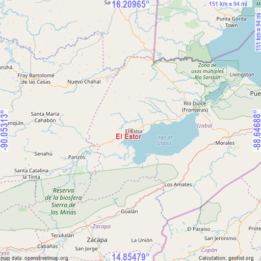
El Estor GPS coordinates[2]
15° 31' 59.988" North, 89° 21' 0" West
| Map corner | latitude | longitude |
|---|---|---|
| Upper-left | 16.20965°, | -90.05313° |
| Center: | 15.53333°, | -89.35° |
| Lower-right: | 14.85479°, | -88.64688° |
| Map W x H: | 150.6×150.6 km | = 93.6×93.6mi |
| max Lat: | 17.06606° ⇑11.2% North |
| El Estor: | 15.53333° |
| min Lat: | ⇓88.8% South 13.9274° |
| min Long | El Estor | max Long |
| -92.19298° | -89.35° | -88.59444° |
| W 98.2%⇐ | ⇒1.8% E |
Elevation
Elevation of El Estor is 92 m = 302 ft, and this is 1175 m = 3855 ft below average elevation for this country.
| Max E: |
3254 m = 10676 ft | 96.2% |
| Avg. | 1267 m = 4157 ft | |
| El Estor | 92 m = 302 ft | |
Min E: |
1 m = 3 ft | 3.8% |
See also: Guatemala elevation on elevation.city.
Geographical zone
El Estor is located in North Torrid zone (between Equator and Tropic of Cancer). Distance of this Northern Tropic circle is 878.8 km =546.1 mi to North.| Distance of | km | miles | from El Estor |
|---|---|---|---|
| North Pole | 8279.9 | 5144.9 | to North |
| Arctic Circle | 5674 | 3525.7 | to North |
| Tropic Cancer | 878.8 | 546.1 | to North |
| Equator | 1727.1 | 1073.2 | to South |


Nearby cities:
15 places around El Estor: (largest is in red/bold)
• Cahabón
50.1 km =31.1 mi,  274°
274°
• Chahal Guatemala
39.6 km =24.6 mi,  316°
316°
• Estanzuela
63.7 km =39.6 mi,  201°
201°
• Fray Bartolomé de Las Casas
65.7 km =40.8 mi,  298°
298°
• Gualán
46 km =28.6 mi,  180°
180°
• La Tinta
62 km =38.5 mi,  247°
247°
• La Unión
63.3 km =39.3 mi,  174°
174°
• Lanquín
66.2 km =41.1 mi, 273°
• Los Amates
41 km =25.5 mi,  138°
138°
• Morales
57.4 km =35.7 mi,  95°
95°
• Panzós
37 km =23 mi, 246°
• Río Hondo
57.6 km =35.8 mi,  205°
205°
• San Jorge
71.3 km =44.3 mi, 200°
• Senahú
53.9 km =33.5 mi, 254°
• Zacapa
65.3 km =40.6 mi, 197°
Sources, notices
• [Note1] Compared only with cities in Guatemala existing in our database
• [Src1] Map data: © OpenStreetMap contributors (CC-BY-SA)
• [Src2] Other city data from geonames.org with taken over terms of usage.
• [Src3] Geographical zone / Annual Mean Temperature by Robert A. Rohde @ Wikipedia
