Unión geodata
Unión (Huehuetenango) is a seat of a second-order administrative division; located in Guatemala in America/Guatemala (GMT-6) time zone. In our database, there are 325 cities with bigger population. Compared to other cities in Guatemala, 95.9% of cities are located further ↓South; 90.3% of cities are located further →East and 63.4% of cities have higher elevation than Unión. Note1


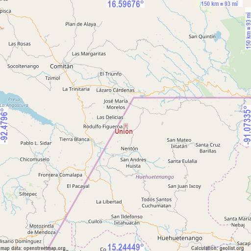
Unión GPS coordinates[2]
15° 55' 18.336" North, 91° 46' 35.292" West
| Map corner | latitude | longitude |
|---|---|---|
| Upper-left | 16.59676°, | -92.4796° |
| Center: | 15.92176°, | -91.77647° |
| Lower-right: | 15.24449°, | -91.07335° |
| Map W x H: | 150.4×150.4 km | = 93.5×93.5mi |
| max Lat: | 17.06606° ⇑4.1% North |
| Unión: | 15.92176° |
| min Lat: | ⇓95.9% South 13.9274° |
| min Long | Unión | max Long |
| -92.19298° | -91.77647° | -88.59444° |
| W 9.7%⇐ | ⇒90.3% E |
Elevation
Elevation of Unión is 892 m = 2927 ft, and this is 375 m = 1230 ft below average elevation for this country.
| Max E: |
3254 m = 10676 ft | 63.4% |
| Avg. | 1267 m = 4157 ft | |
| Unión | 892 m = 2927 ft | |
Min E: |
1 m = 3 ft | 36.6% |
See also: Guatemala elevation on elevation.city.
Geographical zone
Unión is located in North Torrid zone (between Equator and Tropic of Cancer). Distance of this Northern Tropic circle is 835.6 km =519.2 mi to North.| Distance of | km | miles | from Unión |
|---|---|---|---|
| North Pole | 8236.7 | 5118 | to North |
| Arctic Circle | 5630.8 | 3498.8 | to North |
| Tropic Cancer | 835.6 | 519.2 | to North |
| Equator | 1770.3 | 1100 | to South |


Nearby cities:
15 places around Unión: (largest is in red/bold)
• Concepción Huista
35.2 km =21.9 mi,  160°
160°
• Jacaltenango
29.2 km =18.1 mi,  166°
166°
• La Democracia
35 km =21.7 mi,  199°
199°
• La Libertad
46.4 km =28.8 mi,  192°
192°
• Nentón
13.7 km =8.5 mi, 170°
• San Antonio Huista
30.2 km =18.8 mi,  179°
179°
• San Mateo Ixtatán
33.4 km =20.8 mi,  107°
107°
• San Miguel Acatán
30.9 km =19.2 mi,  141°
141°
• San Pedro Necta
47.9 km =29.8 mi, 178°
• San Rafael La Independencia
35.6 km =22.1 mi,  133°
133°
• San Sebastián Coatán
30.8 km =19.1 mi, 132°
• Santa Ana Huista
27.2 km =16.9 mi, 189°
• Santa Eulalia
40.1 km =24.9 mi,  121°
121°
• Soloma
47.2 km =29.3 mi, 128°
• Todos Santos Cuchumatán
49.5 km =30.8 mi, 158°
Sources, notices
• [Note1] Compared only with cities in Guatemala existing in our database
• [Src1] Map data: © OpenStreetMap contributors (CC-BY-SA)
• [Src2] Other city data from geonames.org with taken over terms of usage.
• [Src3] Geographical zone / Annual Mean Temperature by Robert A. Rohde @ Wikipedia
