Lívingston geodata
Lívingston (Izabal) is a seat of a second-order administrative division; located in Guatemala in America/Guatemala (GMT-6) time zone. With population of 14,350 people, there are 85 cities with bigger population in this country. Compared to other cities in Guatemala, 95% of cities are located further ↓South; 99.7% of cities are located further ←West and 98.5% of cities have higher elevation than Lívingston. Note1


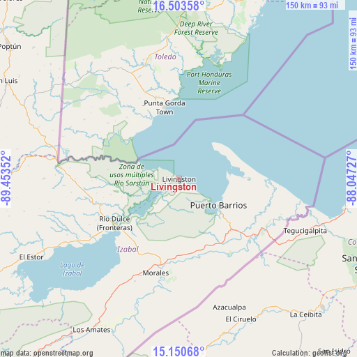
Lívingston GPS coordinates[2]
15° 49' 41.736" North, 88° 45' 1.404" West
| Map corner | latitude | longitude |
|---|---|---|
| Upper-left | 16.50358°, | -89.45352° |
| Center: | 15.82826°, | -88.75039° |
| Lower-right: | 15.15068°, | -88.04727° |
| Map W x H: | 150.4×150.4 km | = 93.5×93.5mi |
| max Lat: | 17.06606° ⇑5% North |
| Lívingston: | 15.82826° |
| min Lat: | ⇓95% South 13.9274° |
| min Long | Lívingston | max Long |
| -92.19298° | -88.75039° | -88.59444° |
| W 99.7%⇐ | ⇒0.3% E |
Elevation
Elevation of Lívingston is 16 m = 52 ft, and this is 1251 m = 4104 ft below average elevation for this country.
| Max E: |
3254 m = 10676 ft | 98.5% |
| Avg. | 1267 m = 4157 ft | |
| Lívingston | 16 m = 52 ft | |
Min E: |
1 m = 3 ft | 1.5% |
See also: Guatemala elevation on elevation.city.
Geographical zone
Lívingston is located in North Torrid zone (between Equator and Tropic of Cancer). Distance of this Northern Tropic circle is 846 km =525.7 mi to North.| Distance of | km | miles | from Lívingston |
|---|---|---|---|
| North Pole | 8247.1 | 5124.5 | to North |
| Arctic Circle | 5641.2 | 3505.3 | to North |
| Tropic Cancer | 846 | 525.7 | to North |
| Equator | 1759.9 | 1093.6 | to South |


Nearby cities:
15 places around Lívingston: (largest is in red/bold)
• Cahabón
117.8 km =73.2 mi,  255°
255°
• Chahal Guatemala
91.5 km =56.9 mi,  267°
267°
• Dolores
104.1 km =64.7 mi,  316°
316°
• El Estor
72.1 km =44.8 mi,  242°
242°
• Fray Bartolomé de Las Casas
121.8 km =75.7 mi, 269°
• Gualán
102.2 km =63.5 mi,  219°
219°
• La Unión
111.9 km =69.5 mi,  211°
211°
• Los Amates
73.6 km =45.7 mi, 210°
• Morales
39 km =24.2 mi,  190°
190°
• Panzós
109.1 km =67.8 mi, 244°
• Poptún
90.5 km =56.2 mi,  308°
308°
• Puerto Barrios
20.1 km =12.5 mi,  123°
123°
• Río Hondo
123 km =76.4 mi,  226°
226°
• San Luis
84.5 km =52.5 mi,  299°
299°
• Senahú
125.4 km =77.9 mi,  247°
247°
Sources, notices
• [Note1] Compared only with cities in Guatemala existing in our database
• [Src1] Map data: © OpenStreetMap contributors (CC-BY-SA)
• [Src2] Other city data from geonames.org with taken over terms of usage.
• [Src3] Geographical zone / Annual Mean Temperature by Robert A. Rohde @ Wikipedia
