Malacatancito geodata
Malacatancito (Huehuetenango) is a seat of a second-order administrative division; located in Guatemala in America/Guatemala (GMT-6) time zone. With population of 2,121 people, there are 273 cities with bigger population in this country. Compared to other cities in Guatemala, 77.3% of cities are located further ↓South; 72.9% of cities are located further →East and 66.4% of cities have lower elevation than Malacatancito. Note1


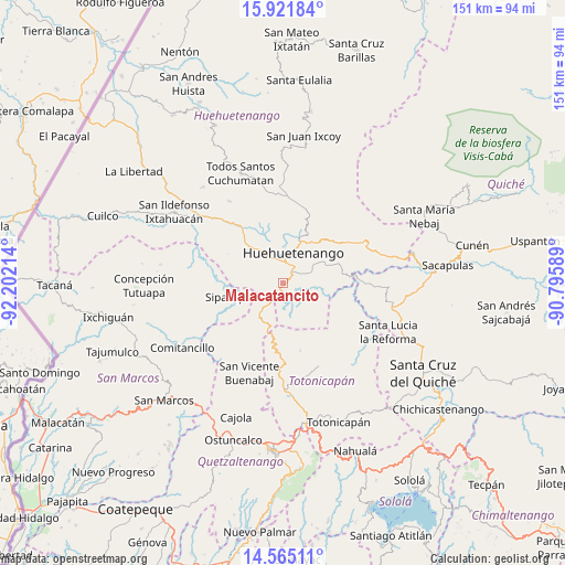
Malacatancito GPS coordinates[2]
15° 14' 40.452" North, 91° 29' 56.436" West
| Map corner | latitude | longitude |
|---|---|---|
| Upper-left | 15.92184°, | -92.20214° |
| Center: | 15.24457°, | -91.49901° |
| Lower-right: | 14.56511°, | -90.79589° |
| Map W x H: | 150.9×150.9 km | = 93.8×93.8mi |
| max Lat: | 17.06606° ⇑22.7% North |
| Malacatancito: | 15.24457° |
| min Lat: | ⇓77.3% South 13.9274° |
| min Long | Malacatancito | max Long |
| -92.19298° | -91.49901° | -88.59444° |
| W 27.1%⇐ | ⇒72.9% E |
Elevation
Elevation of Malacatancito is 1711 m = 5614 ft, and this is 444 m = 1457 ft above average elevation for this country.
| Max E: |
3254 m = 10676 ft | 33.6% |
| Malacatancito | 1711 m 5614 ft | |
| Avg. | 1267 m = 4157 ft | |
Min E: |
1 m = 3 ft | 66.4% |
See also: Guatemala elevation on elevation.city.
Geographical zone
Malacatancito is located in North Torrid zone (between Equator and Tropic of Cancer). Distance of this Northern Tropic circle is 910.9 km =566 mi to North.| Distance of | km | miles | from Malacatancito |
|---|---|---|---|
| North Pole | 8312 | 5164.8 | to North |
| Arctic Circle | 5706.1 | 3545.6 | to North |
| Tropic Cancer | 910.9 | 566 | to North |
| Equator | 1695 | 1053.2 | to South |


Nearby cities:
15 places around Malacatancito: (largest is in red/bold)
• Aguacatán
22.9 km =14.2 mi,  61°
61°
• Cabricán
24.7 km =15.3 mi,  220°
220°
• Chiantla
13 km =8.1 mi,  19°
19°
• Colotenango
29.1 km =18.1 mi,  308°
308°
• Huehuetenango
8.8 km =5.5 mi, 18°
• Huitán
26.4 km =16.4 mi,  214°
214°
• Momostenango
24.3 km =15.1 mi,  156°
156°
• San Bartolo
18.4 km =11.4 mi,  165°
165°
• San Gaspar Ixchil
29.1 km =18.1 mi,  303°
303°
• San Juan Atitán
24.5 km =15.2 mi,  326°
326°
• San Miguel Ixtahuacán
26.9 km =16.7 mi,  276°
276°
• San Rafael Petzal
25.2 km =15.7 mi,  315°
315°
• San Sebastián Huehuetenango
20.2 km =12.6 mi, 321°
• Santa Bárbara
16.4 km =10.2 mi, 299°
• Sipacapa
14.9 km =9.3 mi,  256°
256°
Sources, notices
• [Note1] Compared only with cities in Guatemala existing in our database
• [Src1] Map data: © OpenStreetMap contributors (CC-BY-SA)
• [Src2] Other city data from geonames.org with taken over terms of usage.
• [Src3] Geographical zone / Annual Mean Temperature by Robert A. Rohde @ Wikipedia
