Taszár geodata
Taszár (Somogy) is a populated place; located in Hungary in Europe/Budapest (GMT+2) time zone. With population of 2,013 people, there are 777 cities with bigger population in this country. Compared to other cities in Hungary, 89.7% of cities are located further ↑North; 87% of cities are located further →East and 68.8% of cities have lower elevation than Taszár. Note1


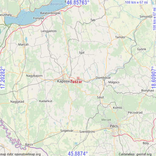
Taszár GPS coordinates[2]
46° 22' 28.812" North, 17° 54' 21.384" East
| Map corner | latitude | longitude |
|---|---|---|
| Upper-left | 46.85763°, | 17.20282° |
| Center: | 46.37467°, | 17.90594° |
| Lower-right: | 45.8874°, | 18.60907° |
| Map W x H: | 107.9×107.9 km | = 67×67mi |
| max Lat: | 48.46667° ⇑89.7% North |
| Taszár: | 46.37467° |
| min Lat: | ⇓10.3% South 45.79108° |
| min Long | Taszár | max Long |
| 16.27358° | 17.90594° | 22.68096° |
| W 13%⇐ | ⇒87% E |
Elevation
Elevation of Taszár is 136 m = 446 ft, and this is 6.3 m = 21 ft above average elevation for this country.
| Max E: |
444 m = 1457 ft | 31.2% |
| Taszár | 136 m 446 ft | |
| Avg. | 129.7 m = 426 ft | |
Min E: |
71 m = 233 ft | 68.8% |
See also: Hungary elevation on elevation.city.
Geographical zone
Taszár is located in North temperate zone (between Tropic of Cancer and the Arctic Circle). Distance of this North polar circle is 2244.8 km =1394.9 mi to North.| Distance of | km | miles | from Taszár |
|---|---|---|---|
| North Pole | 4850.7 | 3014.1 | to North |
| Arctic Circle | 2244.8 | 1394.9 | to North |
| Tropic Cancer | 2550.5 | 1584.8 | to South |
| Equator | 5156.4 | 3204 | to South |


Nearby cities:
15 places around Taszár: (largest is in red/bold)
• Bükkösd
30.4 km =18.9 mi,  167°
167°
• Dombóvár
17.7 km =11 mi,  89°
89°
• Döbrököz
26.1 km =16.2 mi,  78°
78°
• Gödre
11.1 km =6.9 mi,  152°
152°
• Kadarkút
26.8 km =16.7 mi,  234°
234°
• Kaposmérő
15.6 km =9.7 mi,  264°
264°
• Kaposvár
8.2 km =5.1 mi, 263°
• Karád
35.5 km =22.1 mi,  351°
351°
• Komló
34.2 km =21.3 mi,  126°
126°
• Mágocs
25.2 km =15.7 mi,  96°
96°
• Nagybajom
30.3 km =18.8 mi,  273°
273°
• Somogyvár
29.6 km =18.4 mi,  321°
321°
• Szakcs
24 km =14.9 mi,  40°
40°
• Szigetvár
37.1 km =23.1 mi,  192°
192°
• Sásd
20.4 km =12.7 mi, 130°
Sources, notices
• [Note1] Compared only with cities in Hungary existing in our database
• [Src1] Map data: © OpenStreetMap contributors (CC-BY-SA)
• [Src2] Other city data from geonames.org with taken over terms of usage.
• [Src3] Geographical zone / Annual Mean Temperature by Robert A. Rohde @ Wikipedia
