Mór geodata
Mór (Fejér) is a seat of a second-order administrative division; located in Hungary in Europe/Budapest (GMT+2) time zone. With population of 14,690 people, there are 114 cities with bigger population in this country. Compared to other cities in Hungary, 52.6% of cities are located further ↑North; 83% of cities are located further →East and 86.5% of cities have lower elevation than Mór. Note1


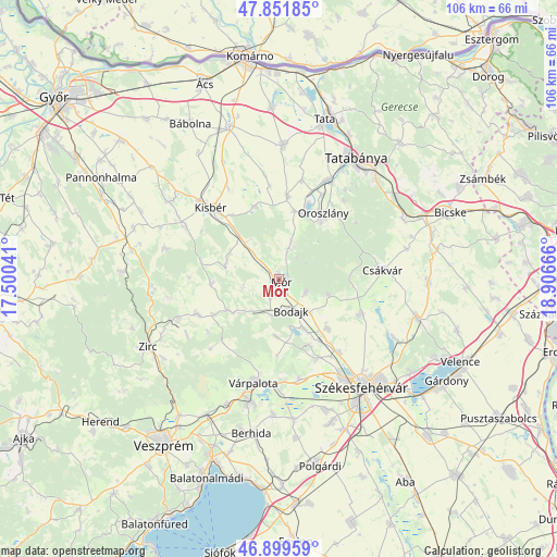
Mór GPS coordinates[2]
47° 22' 40.332" North, 18° 12' 12.708" East
| Map corner | latitude | longitude |
|---|---|---|
| Upper-left | 47.85185°, | 17.50041° |
| Center: | 47.37787°, | 18.20353° |
| Lower-right: | 46.89959°, | 18.90666° |
| Map W x H: | 105.9×105.9 km | = 65.8×65.8mi |
| max Lat: | 48.46667° ⇑52.6% North |
| Mór: | 47.37787° |
| min Lat: | ⇓47.4% South 45.79108° |
| min Long | Mór | max Long |
| 16.27358° | 18.20353° | 22.68096° |
| W 17%⇐ | ⇒83% E |
Elevation
Elevation of Mór is 177 m = 581 ft, and this is 47.3 m = 155 ft above average elevation for this country.
| Max E: |
444 m = 1457 ft | 13.5% |
| Mór | 177 m 581 ft | |
| Avg. | 129.7 m = 426 ft | |
Min E: |
71 m = 233 ft | 86.5% |
See also: Hungary elevation on elevation.city.
Geographical zone
Mór is located in North temperate zone (between Tropic of Cancer and the Arctic Circle). Distance of this North polar circle is 2133.2 km =1325.5 mi to North.| Distance of | km | miles | from Mór |
|---|---|---|---|
| North Pole | 4739.1 | 2944.7 | to North |
| Arctic Circle | 2133.2 | 1325.5 | to North |
| Tropic Cancer | 2662 | 1654.1 | to South |
| Equator | 5267.9 | 3273.3 | to South |


Nearby cities:
15 places around Mór: (largest is in red/bold)
• Bakonycsernye
11.4 km =7.1 mi,  238°
238°
• Bodajk
6.4 km =4 mi,  159°
159°
• Bokod
13.1 km =8.1 mi,  14°
14°
• Csetény
17.3 km =10.7 mi,  247°
247°
• Csákvár
19.7 km =12.2 mi,  85°
85°
• Császár
14.1 km =8.8 mi,  341°
341°
• Ete
19.5 km =12.1 mi,  330°
330°
• Fehérvárcsurgó
10.4 km =6.5 mi,  153°
153°
• Kecskéd
18 km =11.2 mi,  26°
26°
• Kincsesbánya
13.8 km =8.6 mi, 156°
• Kisbér
18.7 km =11.6 mi,  317°
317°
• Oroszlány
14.6 km =9.1 mi, 34°
• Pusztavám
6 km =3.7 mi,  16°
16°
• Várpalota
20.4 km =12.7 mi,  193°
193°
• Zámoly
16.8 km =10.4 mi,  113°
113°
Sources, notices
• [Note1] Compared only with cities in Hungary existing in our database
• [Src1] Map data: © OpenStreetMap contributors (CC-BY-SA)
• [Src2] Other city data from geonames.org with taken over terms of usage.
• [Src3] Geographical zone / Annual Mean Temperature by Robert A. Rohde @ Wikipedia
