Kiskunhalas geodata
Kiskunhalas (Bács-Kiskun) is a seat of a second-order administrative division; located in Hungary in Europe/Budapest (GMT+2) time zone. With population of 29,354 people, there are 61 cities with bigger population in this country. Compared to other cities in Hungary, 87.4% of cities are located further ↑North; 50.3% of cities are located further →East and 61.1% of cities have lower elevation than Kiskunhalas. Note1


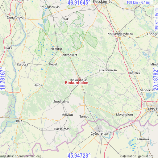
Kiskunhalas GPS coordinates[2]
46° 26' 2.472" North, 19° 29' 5.244" East
| Map corner | latitude | longitude |
|---|---|---|
| Upper-left | 46.91645°, | 18.78167° |
| Center: | 46.43402°, | 19.48479° |
| Lower-right: | 45.94728°, | 20.18792° |
| Map W x H: | 107.8×107.8 km | = 67×67mi |
| max Lat: | 48.46667° ⇑87.4% North |
| Kiskunhalas: | 46.43402° |
| min Lat: | ⇓12.6% South 45.79108° |
| min Long | Kiskunhalas | max Long |
| 16.27358° | 19.48479° | 22.68096° |
| W 49.7%⇐ | ⇒50.3% E |
Elevation
Elevation of Kiskunhalas is 127 m = 417 ft, and this is 2.7 m = 9 ft below average elevation for this country.
| Max E: |
444 m = 1457 ft | 38.9% |
| Avg. | 129.7 m = 426 ft | |
| Kiskunhalas | 127 m = 417 ft | |
Min E: |
71 m = 233 ft | 61.1% |
See also: Hungary elevation on elevation.city.
Geographical zone
Kiskunhalas is located in North temperate zone (between Tropic of Cancer and the Arctic Circle). Distance of this North polar circle is 2238.2 km =1390.8 mi to North.| Distance of | km | miles | from Kiskunhalas |
|---|---|---|---|
| North Pole | 4844.1 | 3010 | to North |
| Arctic Circle | 2238.2 | 1390.8 | to North |
| Tropic Cancer | 2557.1 | 1588.9 | to South |
| Equator | 5163 | 3208.1 | to South |


Nearby cities:
15 places around Kiskunhalas: (largest is in red/bold)
• Császártöltés
23.1 km =14.4 mi,  266°
266°
• Hajós
28.2 km =17.5 mi,  261°
261°
• Jánoshalma
19.4 km =12.1 mi,  219°
219°
• Jászszentlászló
25.8 km =16 mi,  55°
55°
• Kecel
20.5 km =12.7 mi,  299°
299°
• Kiskunmajsa
20.5 km =12.7 mi,  72°
72°
• Kiskőrös
25.8 km =16 mi,  323°
323°
• Kisszállás
17.1 km =10.6 mi,  178°
178°
• Kunfehértó
9.8 km =6.1 mi,  213°
213°
• Mélykút
25.6 km =15.9 mi,  198°
198°
• Ruzsa
25.9 km =16.1 mi,  128°
128°
• Soltvadkert
17.5 km =10.9 mi,  336°
336°
• Szank
19.2 km =11.9 mi,  44°
44°
• Tompa
25.7 km =16 mi,  170°
170°
• Tázlár
12.9 km =8 mi,  10°
10°
Sources, notices
• [Note1] Compared only with cities in Hungary existing in our database
• [Src1] Map data: © OpenStreetMap contributors (CC-BY-SA)
• [Src2] Other city data from geonames.org with taken over terms of usage.
• [Src3] Geographical zone / Annual Mean Temperature by Robert A. Rohde @ Wikipedia
