Jánoshalma geodata
Jánoshalma (Bács-Kiskun) is a seat of a second-order administrative division; located in Hungary in Europe/Budapest (GMT+2) time zone. With population of 9,755 people, there are 171 cities with bigger population in this country. Compared to other cities in Hungary, 92.2% of cities are located further ↑North; 53.8% of cities are located further →East and 68.8% of cities have lower elevation than Jánoshalma. Note1


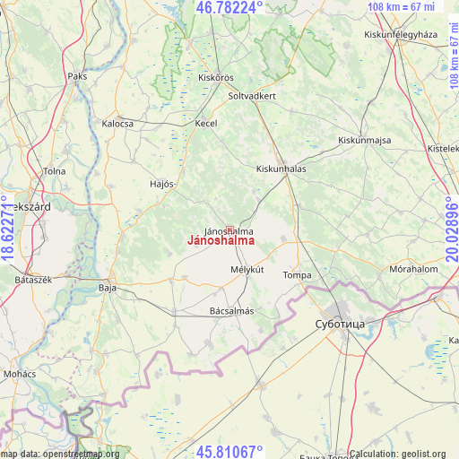
Jánoshalma GPS coordinates[2]
46° 17' 54.996" North, 19° 19' 32.988" East
| Map corner | latitude | longitude |
|---|---|---|
| Upper-left | 46.78224°, | 18.62271° |
| Center: | 46.29861°, | 19.32583° |
| Lower-right: | 45.81067°, | 20.02896° |
| Map W x H: | 108×108 km | = 67.1×67.1mi |
| max Lat: | 48.46667° ⇑92.2% North |
| Jánoshalma: | 46.29861° |
| min Lat: | ⇓7.8% South 45.79108° |
| min Long | Jánoshalma | max Long |
| 16.27358° | 19.32583° | 22.68096° |
| W 46.2%⇐ | ⇒53.8% E |
Elevation
Elevation of Jánoshalma is 136 m = 446 ft, and this is 6.3 m = 21 ft above average elevation for this country.
| Max E: |
444 m = 1457 ft | 31.2% |
| Jánoshalma | 136 m 446 ft | |
| Avg. | 129.7 m = 426 ft | |
Min E: |
71 m = 233 ft | 68.8% |
See also: Hungary elevation on elevation.city.
Geographical zone
Jánoshalma is located in North temperate zone (between Tropic of Cancer and the Arctic Circle). Distance of this North polar circle is 2253.3 km =1400.1 mi to North.| Distance of | km | miles | from Jánoshalma |
|---|---|---|---|
| North Pole | 4859.1 | 3019.3 | to North |
| Arctic Circle | 2253.3 | 1400.1 | to North |
| Tropic Cancer | 2542 | 1579.5 | to South |
| Equator | 5147.9 | 3198.8 | to South |


Nearby cities:
15 places around Jánoshalma: (largest is in red/bold)
• Bácsalmás
19.1 km =11.9 mi,  178°
178°
• Bácsbokod
23.3 km =14.5 mi,  214°
214°
• Császártöltés
17.5 km =10.9 mi,  321°
321°
• Csávoly
18.4 km =11.4 mi,  228°
228°
• Felsőszentiván
15.5 km =9.6 mi,  223°
223°
• Hajós
19.3 km =12 mi,  305°
305°
• Kecel
25.8 km =16 mi,  347°
347°
• Kelebia
25.1 km =15.6 mi,  116°
116°
• Kiskunhalas
19.4 km =12.1 mi,  39°
39°
• Kisszállás
12.7 km =7.9 mi,  99°
99°
• Kunfehértó
9.7 km =6 mi, 44°
• Mélykút
10.2 km =6.3 mi,  155°
155°
• Nemesnádudvar
21.6 km =13.4 mi,  282°
282°
• Sükösd
25.5 km =15.8 mi,  265°
265°
• Tompa
19.4 km =12.1 mi, 122°
Sources, notices
• [Note1] Compared only with cities in Hungary existing in our database
• [Src1] Map data: © OpenStreetMap contributors (CC-BY-SA)
• [Src2] Other city data from geonames.org with taken over terms of usage.
• [Src3] Geographical zone / Annual Mean Temperature by Robert A. Rohde @ Wikipedia
