Mélykút geodata
Mélykút (Bács-Kiskun) is a populated place; located in Hungary in Europe/Budapest (GMT+2) time zone. With population of 5,766 people, there are 265 cities with bigger population in this country. Compared to other cities in Hungary, 95.1% of cities are located further ↑North; 52.8% of cities are located further →East and 66.9% of cities have lower elevation than Mélykút. Note1


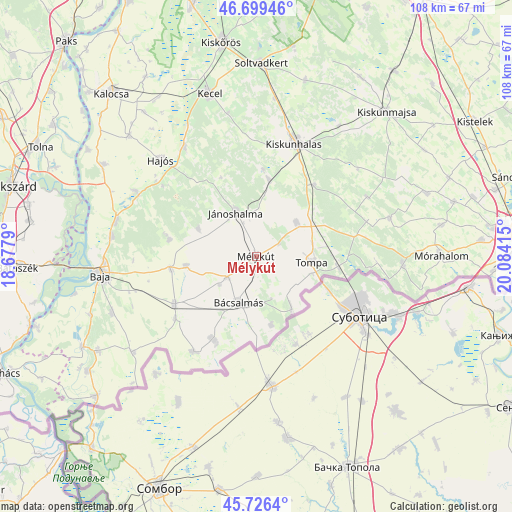
Mélykút GPS coordinates[2]
46° 12' 54.324" North, 19° 22' 51.672" East
| Map corner | latitude | longitude |
|---|---|---|
| Upper-left | 46.69946°, | 18.6779° |
| Center: | 46.21509°, | 19.38102° |
| Lower-right: | 45.7264°, | 20.08415° |
| Map W x H: | 108.2×108.2 km | = 67.2×67.2mi |
| max Lat: | 48.46667° ⇑95.1% North |
| Mélykút: | 46.21509° |
| min Lat: | ⇓4.9% South 45.79108° |
| min Long | Mélykút | max Long |
| 16.27358° | 19.38102° | 22.68096° |
| W 47.2%⇐ | ⇒52.8% E |
Elevation
Elevation of Mélykút is 133 m = 436 ft, and this is 3.3 m = 11 ft above average elevation for this country.
| Max E: |
444 m = 1457 ft | 33.1% |
| Mélykút | 133 m 436 ft | |
| Avg. | 129.7 m = 426 ft | |
Min E: |
71 m = 233 ft | 66.9% |
See also: Hungary elevation on elevation.city.
Geographical zone
Mélykút is located in North temperate zone (between Tropic of Cancer and the Arctic Circle). Distance of this North polar circle is 2262.5 km =1405.9 mi to North.| Distance of | km | miles | from Mélykút |
|---|---|---|---|
| North Pole | 4868.4 | 3025.1 | to North |
| Arctic Circle | 2262.5 | 1405.9 | to North |
| Tropic Cancer | 2532.7 | 1573.7 | to South |
| Equator | 5138.6 | 3193 | to South |


Nearby cities:
15 places around Mélykút: (largest is in red/bold)
• Bácsalmás
10.5 km =6.5 mi,  200°
200°
• Bácsbokod
20 km =12.4 mi,  239°
239°
• Császártöltés
27.5 km =17.1 mi,  326°
326°
• Csávoly
18.3 km =11.4 mi,  260°
260°
• Felsőszentiván
15.1 km =9.4 mi, 262°
• Hajós
28.6 km =17.8 mi,  315°
315°
• Jánoshalma
10.2 km =6.3 mi,  335°
335°
• Katymár
24.1 km =15 mi,  213°
213°
• Kelebia
18.2 km =11.3 mi,  96°
96°
• Kiskunhalas
25.6 km =15.9 mi,  18°
18°
• Kisszállás
11 km =6.8 mi,  49°
49°
• Kunfehértó
16.4 km =10.2 mi,  9°
9°
• Madaras
19.7 km =12.2 mi, 207°
• Nemesnádudvar
28.9 km =18 mi,  298°
298°
• Tompa
12.2 km =7.6 mi,  94°
94°
Sources, notices
• [Note1] Compared only with cities in Hungary existing in our database
• [Src1] Map data: © OpenStreetMap contributors (CC-BY-SA)
• [Src2] Other city data from geonames.org with taken over terms of usage.
• [Src3] Geographical zone / Annual Mean Temperature by Robert A. Rohde @ Wikipedia
