Tanah Merah geodata
Tanah Merah (Papua) is a seat of a second-order administrative division; located in Indonesia in Asia/Jayapura (GMT+9) time zone. In our database, there are 407 cities with bigger population. Compared to other cities in Indonesia, 87.9% of cities are located further ↓South; 99.8% of cities are located further ←West and 74.1% of cities have higher elevation than Tanah Merah. Note1


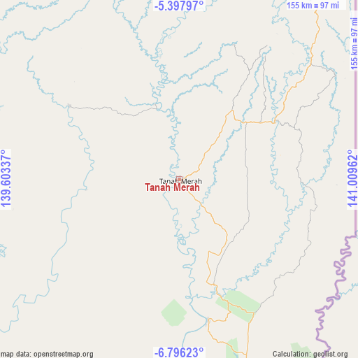
Tanah Merah GPS coordinates[2]
6° 5' 51.216" South, 140° 18' 23.364" East
| Map corner | latitude | longitude |
|---|---|---|
| Upper-left | -5.39797°, | 139.60337° |
| Center: | -6.09756°, | 140.30649° |
| Lower-right: | -6.79623°, | 141.00962° |
| Map W x H: | 155.5×155.5 km | = 96.6×96.6mi |
| max Lat: | 5.88969° ⇑12.1% North |
| Tanah Merah: | -6.09756° |
| min Lat: | ⇓87.9% South -10.934° |
| min Long | Tanah Merah | max Long |
| 95.1345° | 140.30649° | 140.9419° |
| W 99.8%⇐ | ⇒0.2% E |
Elevation
Elevation of Tanah Merah is 26 m = 85 ft, and this is 203.7 m = 668 ft below average elevation for this country.
| Max E: |
3185 m = 10449 ft | 74.1% |
| Avg. | 229.7 m = 754 ft | |
| Tanah Merah | 26 m = 85 ft | |
Min E: |
-1 m = -3 ft | 25.9% |
See also: Indonesia elevation on elevation.city.
Geographical zone
Tanah Merah is located in South Torrid zone (between Equator and Tropic of Capricorn). Distance of Equator is 678 km =421.3 mi to North.| Distance of | km | miles | from Tanah Merah |
|---|---|---|---|
| Equator | 678 | 421.3 | to North |
| Tropic Capricorn | 1927.9 | 1197.9 | to South |
| Antarctic Circle | 6723.2 | 4177.6 | to South |
| South Pole | 9329.1 | 5796.8 | to South |


Nearby cities:
15 places around Tanah Merah: (largest is in red/bold)
• Agats
247.9 km =154 mi,  284°
284°
• Bade
143.2 km =89 mi,  213°
213°
• Eci
127.5 km =79.2 mi,  268°
268°
• Elelim
268.4 km =166.8 mi,  345°
345°
• Getentiri
54.8 km =34.1 mi,  175°
175°
• Kenyam
270.2 km =167.9 mi,  308°
308°
• Kepi
118.7 km =73.8 mi,  246°
246°
• Kimaam
264.5 km =164.4 mi,  217°
217°
• Mindiptana
50 km =31.1 mi,  58°
58°
• Muting
137.4 km =85.4 mi,  168°
168°
• Oksibil
137.4 km =85.4 mi,  15°
15°
• Sengge
299.2 km =185.9 mi,  9°
9°
• Sumohai
188.7 km =117.3 mi,  326°
326°
• Ubrub
272.6 km =169.4 mi, 13°
• Wamena
268.9 km =167.1 mi, 325°
Sources, notices
• [Note1] Compared only with cities in Indonesia existing in our database
• [Src1] Map data: © OpenStreetMap contributors (CC-BY-SA)
• [Src2] Other city data from geonames.org with taken over terms of usage.
• [Src3] Geographical zone / Annual Mean Temperature by Robert A. Rohde @ Wikipedia
