Muting geodata
Muting (Papua) is a seat of a third-order administrative division; located in Indonesia in Asia/Jayapura (GMT+9) time zone. In our database, there are 407 cities with bigger population. Compared to other cities in Indonesia, 50.8% of cities are located further ↓South; 99.9% of cities are located further ←West and 71.2% of cities have higher elevation than Muting. Note1


Muting GPS coordinates[2]
7° 18' 27.324" South, 140° 33' 28.152" East
| Map corner | latitude | longitude |
|---|---|---|
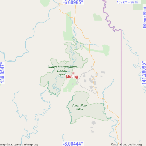
| Upper-left | -6.60965°, | 139.8547° |
| Center: | -7.30759°, | 140.55782° |
| Lower-right: | -8.00444°, | 141.26095° |
| Map W x H: | 155.1×155.1 km | = 96.4×96.4mi |
| max Lat: | 5.88969° ⇑49.2% North |
| Muting: | -7.30759° |
| min Lat: | ⇓50.8% South -10.934° |
| min Long | Muting | max Long |
| 95.1345° | 140.55782° | 140.9419° |
| W 99.9%⇐ | ⇒0.099999999999994% E |
Elevation
Elevation of Muting is 30 m = 98 ft, and this is 199.7 m = 655 ft below average elevation for this country.
| Max E: |
3185 m = 10449 ft | 71.2% |
| Avg. | 229.7 m = 754 ft | |
| Muting | 30 m = 98 ft | |
Min E: |
-1 m = -3 ft | 28.8% |
See also: Indonesia elevation on elevation.city.
Geographical zone
Muting is located in South Torrid zone (between Equator and Tropic of Capricorn). Distance of Equator is 812.5 km =504.9 mi to North.| Distance of | km | miles | from Muting |
|---|---|---|---|
| Equator | 812.5 | 504.9 | to North |
| Tropic Capricorn | 1793.4 | 1114.4 | to South |
| Antarctic Circle | 6588.6 | 4094 | to South |
| South Pole | 9194.5 | 5713.2 | to South |


Nearby cities:
15 places around Muting: (largest is in red/bold)
• Agats
331.7 km =206.1 mi,  306°
306°
• Bade
108.6 km =67.5 mi,  278°
278°
• Eci
203.4 km =126.4 mi, 310°
• Elelim
405.6 km =252 mi,  346°
346°
• Getentiri
83.3 km =51.8 mi,  343°
343°
• Kenyam
385.3 km =239.4 mi,  321°
321°
• Kepi
161.8 km =100.5 mi,  302°
302°
• Kimaam
203 km =126.1 mi,  248°
248°
• Mindiptana
161.2 km =100.2 mi,  5°
5°
• Oksibil
267.4 km =166.2 mi,  1°
1°
• Sengge
429.9 km =267.1 mi, 3°
• Sumohai
320.1 km =198.9 mi, 335°
• Tanah Merah
137.4 km =85.4 mi, 348°
• Ubrub
401.3 km =249.4 mi, 5°
• Wamena
399.3 km =248.1 mi,  333°
333°
Sources, notices
• [Note1] Compared only with cities in Indonesia existing in our database
• [Src1] Map data: © OpenStreetMap contributors (CC-BY-SA)
• [Src2] Other city data from geonames.org with taken over terms of usage.
• [Src3] Geographical zone / Annual Mean Temperature by Robert A. Rohde @ Wikipedia
