Kepi geodata
Kepi (Papua) is a seat of a second-order administrative division; located in Indonesia in Asia/Jayapura (GMT+9) time zone. In our database, there are 407 cities with bigger population. Compared to other cities in Indonesia, 84% of cities are located further ↓South; 99.8% of cities are located further ←West and 87.7% of cities have higher elevation than Kepi. Note1


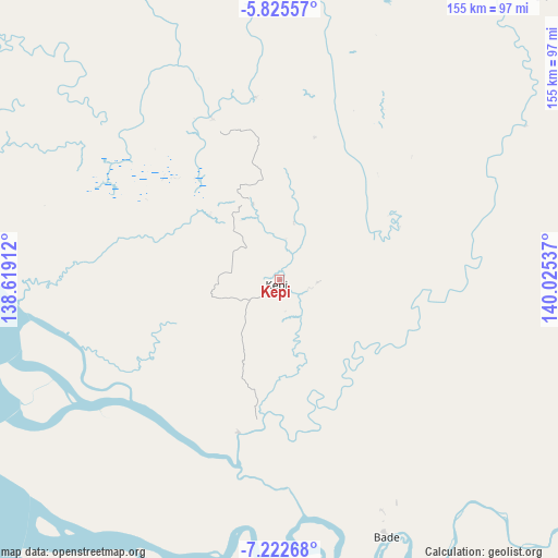
Kepi GPS coordinates[2]
6° 31' 28.596" South, 139° 19' 20.064" East
| Map corner | latitude | longitude |
|---|---|---|
| Upper-left | -5.82557°, | 138.61912° |
| Center: | -6.52461°, | 139.32224° |
| Lower-right: | -7.22268°, | 140.02537° |
| Map W x H: | 155.3×155.3 km | = 96.5×96.5mi |
| max Lat: | 5.88969° ⇑16% North |
| Kepi: | -6.52461° |
| min Lat: | ⇓84% South -10.934° |
| min Long | Kepi | max Long |
| 95.1345° | 139.32224° | 140.9419° |
| W 99.8%⇐ | ⇒0.2% E |
Elevation
Elevation of Kepi is 12 m = 39 ft, and this is 217.7 m = 714 ft below average elevation for this country.
| Max E: |
3185 m = 10449 ft | 87.7% |
| Avg. | 229.7 m = 754 ft | |
| Kepi | 12 m = 39 ft | |
Min E: |
-1 m = -3 ft | 12.3% |
See also: Indonesia elevation on elevation.city.
Geographical zone
Kepi is located in South Torrid zone (between Equator and Tropic of Capricorn). Distance of Equator is 725.5 km =450.8 mi to North.| Distance of | km | miles | from Kepi |
|---|---|---|---|
| Equator | 725.5 | 450.8 | to North |
| Tropic Capricorn | 1880.5 | 1168.5 | to South |
| Antarctic Circle | 6675.7 | 4148.1 | to South |
| South Pole | 9281.6 | 5767.3 | to South |


Nearby cities:
15 places around Kepi: (largest is in red/bold)
• Agats
170.6 km =106 mi,  309°
309°
• Bade
77 km =47.8 mi,  158°
158°
• Eci
48.3 km =30 mi,  337°
337°
• Elelim
310.5 km =192.9 mi,  7°
7°
• Getentiri
113.3 km =70.4 mi,  93°
93°
• Kenyam
237.9 km =147.8 mi,  334°
334°
• Kimaam
170.6 km =106 mi,  197°
197°
• Mindiptana
168.3 km =104.6 mi,  64°
64°
• Muting
161.8 km =100.5 mi,  122°
122°
• Oksibil
231.1 km =143.6 mi,  38°
38°
• Sumohai
204.1 km =126.8 mi,  1°
1°
• Tanah Merah
118.7 km =73.8 mi,  66°
66°
• Tiom
304.7 km =189.3 mi, 341°
• Wamena
273.3 km =169.8 mi,  351°
351°
• Wurigelebur
312.3 km =194.1 mi, 349°
Sources, notices
• [Note1] Compared only with cities in Indonesia existing in our database
• [Src1] Map data: © OpenStreetMap contributors (CC-BY-SA)
• [Src2] Other city data from geonames.org with taken over terms of usage.
• [Src3] Geographical zone / Annual Mean Temperature by Robert A. Rohde @ Wikipedia
