Thurles geodata
Thurles (Munster) is a populated place; located in Ireland in Europe/Dublin (GMT+1) time zone. With population of 7,588 people, there are 87 cities with bigger population in this country. Compared to other cities in Ireland, 72.7% of cities are located further ↑North; 59.2% of cities are located further →East and 88.6% of cities have lower elevation than Thurles. Note1


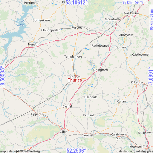
Thurles GPS coordinates[2]
52° 40' 54.984" North, 7° 48' 7.992" West
| Map corner | latitude | longitude |
|---|---|---|
| Upper-left | 53.10612°, | -8.50535° |
| Center: | 52.68194°, | -7.80222° |
| Lower-right: | 52.2536°, | -7.0991° |
| Map W x H: | 94.8×94.8 km | = 58.9×58.9mi |
| max Lat: | 55.25° ⇑72.7% North |
| Thurles: | 52.68194° |
| min Lat: | ⇓27.3% South 51.52487° |
| min Long | Thurles | max Long |
| -10.26889° | -7.80222° | -6.04944° |
| W 40.8%⇐ | ⇒59.2% E |
Elevation
Elevation of Thurles is 102 m = 335 ft, and this is 47.5 m = 156 ft above average elevation for this country.
| Max E: |
262 m = 860 ft | 11.4% |
| Thurles | 102 m 335 ft | |
| Avg. | 54.5 m = 179 ft | |
Min E: |
0 m = 0 ft | 88.6% |
See also: Ireland elevation on elevation.city.
Geographical zone
Thurles is located in North temperate zone (between Tropic of Cancer and the Arctic Circle). Distance of this North polar circle is 1543.5 km =959.1 mi to North.| Distance of | km | miles | from Thurles |
|---|---|---|---|
| North Pole | 4149.4 | 2578.3 | to North |
| Arctic Circle | 1543.5 | 959.1 | to North |
| Tropic Cancer | 3251.8 | 2020.6 | to South |
| Equator | 5857.7 | 3639.8 | to South |


Nearby cities:
15 places around Thurles: (largest is in red/bold)
• Ballyclerahan
30.2 km =18.8 mi,  174°
174°
• Borrisoleigh
12.8 km =8 mi,  307°
307°
• Callan
31.7 km =19.7 mi,  118°
118°
• Cashel
19.3 km =12 mi,  196°
196°
• Cloughjordan
32.7 km =20.3 mi,  331°
331°
• Doon
31.1 km =19.3 mi,  253°
253°
• Fethard
25 km =15.5 mi,  162°
162°
• Freshford
27.8 km =17.3 mi,  77°
77°
• Holycross
6.2 km =3.9 mi,  221°
221°
• Killenaule
15.4 km =9.6 mi,  145°
145°
• Rathdowney
24.3 km =15.1 mi,  37°
37°
• Roscrea
29.9 km =18.6 mi,  0°
0°
• Templemore
12.7 km =7.9 mi,  350°
350°
• Twomileborris
5.7 km =3.5 mi,  101°
101°
• Urlingford
15.4 km =9.6 mi,  73°
73°
Sources, notices
• [Note1] Compared only with cities in Ireland existing in our database
• [Src1] Map data: © OpenStreetMap contributors (CC-BY-SA)
• [Src2] Other city data from geonames.org with taken over terms of usage.
• [Src3] Geographical zone / Annual Mean Temperature by Robert A. Rohde @ Wikipedia
