Templemore geodata
Templemore (Munster) is a populated place; located in Ireland in Europe/Dublin (GMT+0) time zone. With population of 2,264 people, there are 217 cities with bigger population in this country. Compared to other cities in Ireland, 68.7% of cities are located further ↑North; 59.8% of cities are located further →East and 93% of cities have lower elevation than Templemore. Note1


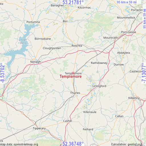
Templemore GPS coordinates[2]
52° 47' 40.992" North, 7° 50' 2.004" West
| Map corner | latitude | longitude |
|---|---|---|
| Upper-left | 53.21781°, | -8.53702° |
| Center: | 52.79472°, | -7.83389° |
| Lower-right: | 52.36748°, | -7.13077° |
| Map W x H: | 94.5×94.5 km | = 58.7×58.7mi |
| max Lat: | 55.25° ⇑68.7% North |
| Templemore: | 52.79472° |
| min Lat: | ⇓31.3% South 51.52487° |
| min Long | Templemore | max Long |
| -10.26889° | -7.83389° | -6.04944° |
| W 40.2%⇐ | ⇒59.8% E |
Elevation
Elevation of Templemore is 114 m = 374 ft, and this is 59.5 m = 195 ft above average elevation for this country.
| Max E: |
262 m = 860 ft | 7% |
| Templemore | 114 m 374 ft | |
| Avg. | 54.5 m = 179 ft | |
Min E: |
0 m = 0 ft | 93% |
See also: Ireland elevation on elevation.city.
Geographical zone
Templemore is located in North temperate zone (between Tropic of Cancer and the Arctic Circle). Distance of this North polar circle is 1531 km =951.3 mi to North.| Distance of | km | miles | from Templemore |
|---|---|---|---|
| North Pole | 4136.8 | 2570.5 | to North |
| Arctic Circle | 1531 | 951.3 | to North |
| Tropic Cancer | 3264.3 | 2028.3 | to South |
| Equator | 5870.2 | 3647.6 | to South |


Nearby cities:
15 places around Templemore: (largest is in red/bold)
• Borrisokane
29.8 km =18.5 mi,  318°
318°
• Borrisoleigh
9.3 km =5.8 mi,  239°
239°
• Cloughjordan
21.1 km =13.1 mi, 320°
• Durrow
30.2 km =18.8 mi,  79°
79°
• Freshford
30 km =18.6 mi,  102°
102°
• Holycross
17.3 km =10.7 mi,  186°
186°
• Killenaule
27.5 km =17.1 mi,  156°
156°
• Nenagh
25.5 km =15.8 mi,  287°
287°
• Nenagh Bridge
26.2 km =16.3 mi, 291°
• Rathdowney
18.3 km =11.4 mi,  68°
68°
• Roscrea
17.5 km =10.9 mi,  7°
7°
• Shinrone
21.7 km =13.5 mi,  343°
343°
• Thurles
12.7 km =7.9 mi,  170°
170°
• Twomileborris
15.7 km =9.8 mi,  150°
150°
• Urlingford
18.8 km =11.7 mi,  115°
115°
Sources, notices
• [Note1] Compared only with cities in Ireland existing in our database
• [Src1] Map data: © OpenStreetMap contributors (CC-BY-SA)
• [Src2] Other city data from geonames.org with taken over terms of usage.
• [Src3] Geographical zone / Annual Mean Temperature by Robert A. Rohde @ Wikipedia
