Bailieborough geodata
Bailieborough (Ulster) is a populated place; located in Ireland in Europe/Dublin (GMT+1) time zone. With population of 2,530 people, there are 204 cities with bigger population in this country. Compared to other cities in Ireland, 84.8% of cities are located further ↓South; 59.8% of cities are located further ←West and 97.3% of cities have lower elevation than Bailieborough. Note1


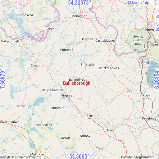
Bailieborough GPS coordinates[2]
53° 55' 0.012" North, 6° 58' 0.012" West
| Map corner | latitude | longitude |
|---|---|---|
| Upper-left | 54.32873°, | -7.66979° |
| Center: | 53.91667°, | -6.96667° |
| Lower-right: | 53.5005°, | -6.26354° |
| Map W x H: | 92.1×92.1 km | = 57.2×57.2mi |
| max Lat: | 55.25° ⇑15.2% North |
| Bailieborough: | 53.91667° |
| min Lat: | ⇓84.8% South 51.52487° |
| min Long | Bailieborough | max Long |
| -10.26889° | -6.96667° | -6.04944° |
| W 59.8%⇐ | ⇒40.2% E |
Elevation
Elevation of Bailieborough is 146 m = 479 ft, and this is 91.5 m = 300 ft above average elevation for this country.
| Max E: |
262 m = 860 ft | 2.7% |
| Bailieborough | 146 m 479 ft | |
| Avg. | 54.5 m = 179 ft | |
Min E: |
0 m = 0 ft | 97.3% |
See also: Ireland elevation on elevation.city.
Geographical zone
Bailieborough is located in North temperate zone (between Tropic of Cancer and the Arctic Circle). Distance of this North polar circle is 1406.2 km =873.8 mi to North.| Distance of | km | miles | from Bailieborough |
|---|---|---|---|
| North Pole | 4012.1 | 2493 | to North |
| Arctic Circle | 1406.2 | 873.8 | to North |
| Tropic Cancer | 3389.1 | 2105.9 | to South |
| Equator | 5995 | 3725.1 | to South |


Nearby cities:
15 places around Bailieborough: (largest is in red/bold)
• Ballyhaise
27.3 km =17 mi,  302°
302°
• Ballyjamesduff
16.5 km =10.3 mi,  249°
249°
• Carlanstown
19.3 km =12 mi,  154°
154°
• Carrickmacross
17.4 km =10.8 mi,  68°
68°
• Castleblayney
27 km =16.8 mi,  34°
34°
• Cavan
27.1 km =16.8 mi,  287°
287°
• Cootehill
18.9 km =11.7 mi,  336°
336°
• Kells
21.9 km =13.6 mi,  164°
164°
• Kingscourt
10.6 km =6.6 mi,  95°
95°
• Louth
28.1 km =17.5 mi,  82°
82°
• Mullagh
11.6 km =7.2 mi,  175°
175°
• Oldcastle
21.1 km =13.1 mi,  217°
217°
• Shercock
10.2 km =6.3 mi, 25°
• Tallanstown
27.5 km =17.1 mi,  88°
88°
• Virginia
11.6 km =7.2 mi, 217°
Sources, notices
• [Note1] Compared only with cities in Ireland existing in our database
• [Src1] Map data: © OpenStreetMap contributors (CC-BY-SA)
• [Src2] Other city data from geonames.org with taken over terms of usage.
• [Src3] Geographical zone / Annual Mean Temperature by Robert A. Rohde @ Wikipedia
